

Kingussie, Glen Tromie and Gaick
A cycling route starting in Kingussie, Scotland, United Kingdom.
Overview
About this route
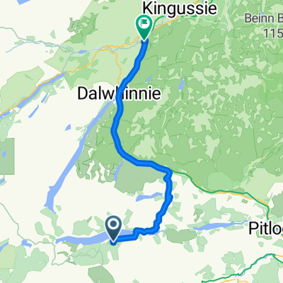
This is a serious route of 53km / 33 miles leading into a remote glen. Suitable for mountain bikes. Some sections are on tarmac but long sections are on rough Land Rover tracks and at one point requires fording a river. Allow 5 hours. Ordinance Survey sheets 35 - Kingussie and Monadliath Mountains, 42 - Glen Garry and Loch Rannoch Refreshments: Cafes and bars in Kingussie. Start in Kingussie town centre and take the B970 quiet minor road past the Ruthven Barracks. After one and half miles take the grassy land-rover track which forks off to the right through a gate. Follow this track through moorland and trees along the west side of the river Tromie until you arrive at the keepers house for Glen Tromie Lodge. Cross the river by the bridge here and turn right on the land-rover track leading up the east side of the Tromie. The track then passes through a section of trees, past Lynaberack Lodge where the surface becomes tarmac and then crosses the river via a bridge. Always follow the main track, ignoring any side tracks to left or right. When the route reaches Tromie Dam the tarmaced road ends and the track becomes a well maintained Land Rover track. Pass Loch an t-Seilach and the Gaick Lodge where the track becomes more rough. Just after the lodge at a fork in the road turn right to cross the river again at a ford. Care will have to be taken here and if the river level is too high the route ends here. If the water is passable it is best to wade across rather than attempt to cycle. After passing Loch Bhrodainn on the right the track becomes steeper and reaches Loch an Duin, although this routes ends where the land rover track ends before quite reaching the loch. After a deserved rest, turn around and enjoy the much easier return back down Glen Tromie by the outbound route. It is also possible to extend the route if there has not been too much recent rainfall via a track on the east side of Loch Duin. This joins another Land Rover track which leads eventually to Dalnacardoch Lodge. From here it is possible to join the Sustrans Route 7 running northwards leading back to Newtonmore and Kingussie.
- -:--
- Duration
- 26.5 km
- Distance
- 313 m
- Ascent
- 57 m
- Descent
- ---
- Avg. speed
- ---
- Max. altitude

Route quality
Waytypes & surfaces along the route
Waytypes
Track
10.3 km
(39 %)
Quiet road
10.1 km
(38 %)
Surfaces
Paved
10.9 km
(41 %)
Unpaved
12.7 km
(48 %)
Asphalt
10.6 km
(40 %)
Unpaved (undefined)
6.4 km
(24 %)
Route highlights
Points of interest along the route

Photo after 4.6 km
Bridge at Tromie Lodge

Photo after 14.3 km
Bridge over Tromie

Photo after 20.4 km
Gaick Lodge
Continue with Bikemap
Use, edit, or download this cycling route
You would like to ride Kingussie, Glen Tromie and Gaick or customize it for your own trip? Here is what you can do with this Bikemap route:
Free features
- Save this route as favorite or in collections
- Copy & plan your own version of this route
- Sync your route with Garmin or Wahoo
Premium features
Free trial for 3 days, or one-time payment. More about Bikemap Premium.
- Navigate this route on iOS & Android
- Export a GPX / KML file of this route
- Create your custom printout (try it for free)
- Download this route for offline navigation
Discover more Premium features.
Get Bikemap PremiumFrom our community
Other popular routes starting in Kingussie
 Kingussie/Inverness via Corrieyairack
- Distance
- 104.2 km
- Ascent
- 960 m
- Descent
- 1,177 m
- Location
- Kingussie, Scotland, United Kingdom
 Day 2 Copathlon
- Distance
- 340.8 km
- Ascent
- 870 m
- Descent
- 1,102 m
- Location
- Kingussie, Scotland, United Kingdom
 Kingussie, Newtonmore Wild Cat trail and Loch Gynack
- Distance
- 16 km
- Ascent
- 219 m
- Descent
- 219 m
- Location
- Kingussie, Scotland, United Kingdom
 Kingussie, Glen Tromie and Gaick
- Distance
- 26.5 km
- Ascent
- 313 m
- Descent
- 57 m
- Location
- Kingussie, Scotland, United Kingdom
 Von Kingussie Versuch nach Fort Augustus
- Distance
- 47.4 km
- Ascent
- 644 m
- Descent
- 531 m
- Location
- Kingussie, Scotland, United Kingdom
 Loch Rannoch to Invernahavon
- Distance
- 59.7 km
- Ascent
- 614 m
- Descent
- 587 m
- Location
- Kingussie, Scotland, United Kingdom
 From Crubenberg to Carrbridge
- Distance
- 57.2 km
- Ascent
- 394 m
- Descent
- 436 m
- Location
- Kingussie, Scotland, United Kingdom
 Kingussie to FeshieBridge 2
- Distance
- 27.6 km
- Ascent
- 235 m
- Descent
- 235 m
- Location
- Kingussie, Scotland, United Kingdom
Open it in the app