

Die schönsten Straßen im Chiemgau 1
A cycling route starting in Rosenheim, Bavaria, Germany.
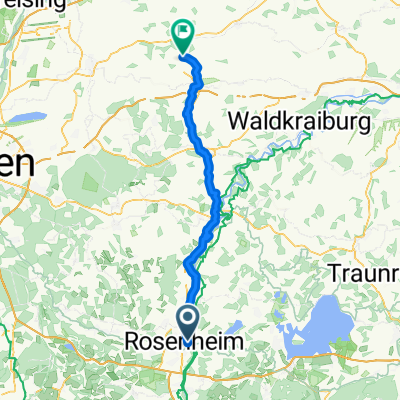
Overview
About this route
Pleasure tour through Chiemgau, southeast of Rosenheim. Almost entirely on secondary roads and with many opportunities to shorten.
- -:--
- Duration
- 61.2 km
- Distance
- 908 m
- Ascent
- 908 m
- Descent
- ---
- Avg. speed
- ---
- Max. altitude
Continue with Bikemap
Use, edit, or download this cycling route
You would like to ride Die schönsten Straßen im Chiemgau 1 or customize it for your own trip? Here is what you can do with this Bikemap route:
Free features
- Save this route as favorite or in collections
- Copy & plan your own version of this route
- Sync your route with Garmin or Wahoo
Premium features
Free trial for 3 days, or one-time payment. More about Bikemap Premium.
- Navigate this route on iOS & Android
- Export a GPX / KML file of this route
- Create your custom printout (try it for free)
- Download this route for offline navigation
Discover more Premium features.
Get Bikemap PremiumFrom our community
Other popular routes starting in Rosenheim
 Radeln rund um Rosenheim - SUR Radweg (Rundweg Nord)
- Distance
- 36.5 km
- Ascent
- 131 m
- Descent
- 130 m
- Location
- Rosenheim, Bavaria, Germany
 Kirchdorf am Inn - Rosenheim (Zellerhornstrasse)
- Distance
- 8.8 km
- Ascent
- 22 m
- Descent
- 14 m
- Location
- Rosenheim, Bavaria, Germany
 Vom Inndamm auf den Samerberg über den Dandlberg
- Distance
- 52.8 km
- Ascent
- 469 m
- Descent
- 469 m
- Location
- Rosenheim, Bavaria, Germany
 Ultimative Transalp - Tour de France
- Distance
- 496.7 km
- Ascent
- 1,033 m
- Descent
- 1,476 m
- Location
- Rosenheim, Bavaria, Germany
 Girolibero:Chiemsee
- Distance
- 201 km
- Ascent
- 432 m
- Descent
- 432 m
- Location
- Rosenheim, Bavaria, Germany
 Rosenheim - Taufkirchen
- Distance
- 64.3 km
- Ascent
- 595 m
- Descent
- 555 m
- Location
- Rosenheim, Bavaria, Germany
 Oberland-Irschenberg Runde
- Distance
- 105.4 km
- Ascent
- 500 m
- Descent
- 500 m
- Location
- Rosenheim, Bavaria, Germany
 Rosenheim to ChiemSee
- Distance
- 38.6 km
- Ascent
- 267 m
- Descent
- 196 m
- Location
- Rosenheim, Bavaria, Germany
Open it in the app