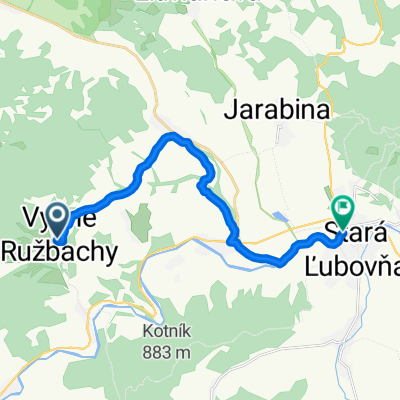
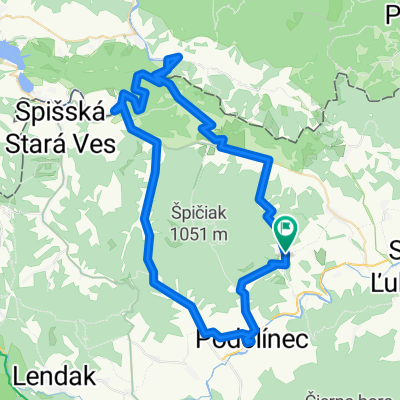
SL okruh
A cycling route starting in Vysne Ruzbachy, Prešov Region, Slovakia.
Overview
About this route
You can write more information here to help other users with your route.* Route progression.* What makes the road special?* Why recommend the route?* What are the main points?* Etc.
- -:--
- Duration
- 63.3 km
- Distance
- 892 m
- Ascent
- 912 m
- Descent
- ---
- Avg. speed
- 754 m
- Max. altitude
Route quality
Waytypes & surfaces along the route
Waytypes
Road
19.6 km
(31 %)
Quiet road
4.4 km
(7 %)
Surfaces
Paved
55.7 km
(88 %)
Asphalt
55.7 km
(88 %)
Undefined
7.6 km
(12 %)
Route highlights
Points of interest along the route
Point of interest after 11.8 km
Point of interest after 61 km
Point of interest after 61.1 km
Point of interest after 61.2 km
Continue with Bikemap
Use, edit, or download this cycling route
You would like to ride SL okruh or customize it for your own trip? Here is what you can do with this Bikemap route:
Free features
- Save this route as favorite or in collections
- Copy & plan your own version of this route
- Sync your route with Garmin or Wahoo
Premium features
Free trial for 3 days, or one-time payment. More about Bikemap Premium.
- Navigate this route on iOS & Android
- Export a GPX / KML file of this route
- Create your custom printout (try it for free)
- Download this route for offline navigation
Discover more Premium features.
Get Bikemap PremiumFrom our community
Other popular routes starting in Vysne Ruzbachy
- EBT 02 2015
- Distance
- 29.4 km
- Ascent
- 438 m
- Descent
- 628 m
- Location
- Vysne Ruzbachy, Prešov Region, Slovakia
- Haligovce - Sromowce Nizne - Niedzica - Debno - Kroscienko nad Dunajcem - Szczawnica - Lesnica - Veľký Lipník - Haligovce
- Distance
- 65.6 km
- Ascent
- 671 m
- Descent
- 671 m
- Location
- Vysne Ruzbachy, Prešov Region, Slovakia
- Vyšné Ružbachy do Unnamed Road, Vyšné Ružbachy
- Distance
- 2 km
- Ascent
- 18 m
- Descent
- 145 m
- Location
- Vysne Ruzbachy, Prešov Region, Slovakia
- Haligovce - Stará Ľubovńa - Litmanová - Biala Voda/PL/ - Jaworky/PL/ - Szczawnica/PL/ - lesnica - Prielom Dunajca - Červený Kláštor - Haligovce
- Distance
- 73.4 km
- Ascent
- 845 m
- Descent
- 845 m
- Location
- Vysne Ruzbachy, Prešov Region, Slovakia
- Veterný vrch
- Distance
- 20.5 km
- Ascent
- 589 m
- Descent
- 596 m
- Location
- Vysne Ruzbachy, Prešov Region, Slovakia
- 20.04.2019 Góry Lewockie
- Distance
- 74.6 km
- Ascent
- 831 m
- Descent
- 832 m
- Location
- Vysne Ruzbachy, Prešov Region, Slovakia
- Vyš.Ružbachy- Hniezdne- St., N.Ľub.- Ľub. kúpele
- Distance
- 23.7 km
- Ascent
- 328 m
- Descent
- 358 m
- Location
- Vysne Ruzbachy, Prešov Region, Slovakia
- SL okruh
- Distance
- 63.3 km
- Ascent
- 892 m
- Descent
- 912 m
- Location
- Vysne Ruzbachy, Prešov Region, Slovakia
Open it in the app