

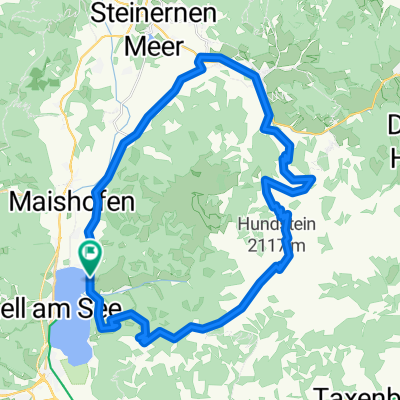
über Thumersbach zum Jagereck
A cycling route starting in Zell am See, Salzburg, Austria.
Overview
About this route
von Schüttdorf-Kitzsteinhornstraße nach Thumersbach. Hinter der Schule gleich nach rechts auf den Berg. Der Straße folgen, alle Abzweigungen ignorieren. Ab dem Schranken gehts auf einem Forstweg weiter. Vorbei an der Enzianhütte (nette Einkehr) immer weiter bergauf. Bei einer Wegkreuzung (mit Bank) gehts links bergauf zum Hundsstein, das sparen wir uns heute. Bei dieser Tour gehts rechts weg Richtung Sender, immer bergab bis nach Bruck
Schöne Tour mit herrlicher Aussicht, nicht allzu anstrengend
- -:--
- Duration
- 22.5 km
- Distance
- 1,117 m
- Ascent
- 1,015 m
- Descent
- ---
- Avg. speed
- 1,505 m
- Max. altitude

Route quality
Waytypes & surfaces along the route
Waytypes
Quiet road
9.4 km
(42 %)
Track
8.5 km
(38 %)
Surfaces
Paved
13.2 km
(59 %)
Unpaved
8.4 km
(37 %)
Asphalt
13 km
(58 %)
Gravel
8.4 km
(37 %)
Continue with Bikemap
Use, edit, or download this cycling route
You would like to ride über Thumersbach zum Jagereck or customize it for your own trip? Here is what you can do with this Bikemap route:
Free features
- Save this route as favorite or in collections
- Copy & plan your own version of this route
- Sync your route with Garmin or Wahoo
Premium features
Free trial for 3 days, or one-time payment. More about Bikemap Premium.
- Navigate this route on iOS & Android
- Export a GPX / KML file of this route
- Create your custom printout (try it for free)
- Download this route for offline navigation
Discover more Premium features.
Get Bikemap PremiumFrom our community
Other popular routes starting in Zell am See
 Zell/See nach Heiligenblut am Großglockner
- Distance
- 53.7 km
- Ascent
- 2,471 m
- Descent
- 1,956 m
- Location
- Zell am See, Salzburg, Austria
 IRONMAN 70.3 Zell am See / Kaprun
- Distance
- 89.7 km
- Ascent
- 802 m
- Descent
- 804 m
- Location
- Zell am See, Salzburg, Austria
 Zellerstraße, Zell am See nach Römerstraße, Untertauern
- Distance
- 108.4 km
- Ascent
- 3,144 m
- Descent
- 2,174 m
- Location
- Zell am See, Salzburg, Austria
 waldheim-enzianhuette_tour_174612738
- Distance
- 13.3 km
- Ascent
- 522 m
- Descent
- 519 m
- Location
- Zell am See, Salzburg, Austria
 Zell am See - Bad Gastein
- Distance
- 52.2 km
- Ascent
- 1,101 m
- Descent
- 802 m
- Location
- Zell am See, Salzburg, Austria
 PŘ 1z - AT2006 - Zell am See - Hundstein
- Distance
- 46.4 km
- Ascent
- 1,498 m
- Descent
- 1,498 m
- Location
- Zell am See, Salzburg, Austria
 ZA3 Schmittenhöhe 31.7.2017
- Distance
- 39.3 km
- Ascent
- 1,392 m
- Descent
- 1,391 m
- Location
- Zell am See, Salzburg, Austria
 Hundstein
- Distance
- 42 km
- Ascent
- 1,413 m
- Descent
- 1,413 m
- Location
- Zell am See, Salzburg, Austria
Open it in the app