

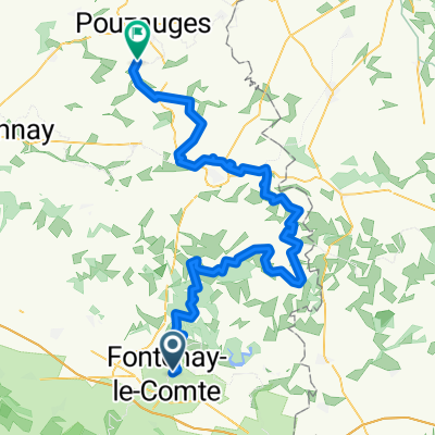
Parcours du 14 juillet (inédit)
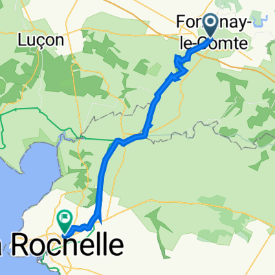
A cycling route starting in Fontenay-le-Comte, Pays de la Loire Region, France.
Overview
About this route
flat course becoming bumpy (forest massif) then alternating flat, bumps
- -:--
- Duration
- 91.2 km
- Distance
- 492 m
- Ascent
- 492 m
- Descent
- ---
- Avg. speed
- ---
- Max. altitude
Route quality
Waytypes & surfaces along the route
Waytypes
Road
57.5 km
(63 %)
Quiet road
20.1 km
(22 %)
Surfaces
Paved
4.6 km
(5 %)
Asphalt
4.6 km
(5 %)
Undefined
86.7 km
(95 %)
Continue with Bikemap
Use, edit, or download this cycling route
You would like to ride Parcours du 14 juillet (inédit) or customize it for your own trip? Here is what you can do with this Bikemap route:
Free features
- Save this route as favorite or in collections
- Copy & plan your own version of this route
- Split it into stages to create a multi-day tour
- Sync your route with Garmin or Wahoo
Premium features
Free trial for 3 days, or one-time payment. More about Bikemap Premium.
- Navigate this route on iOS & Android
- Export a GPX / KML file of this route
- Create your custom printout (try it for free)
- Download this route for offline navigation
Discover more Premium features.
Get Bikemap PremiumFrom our community
Other popular routes starting in Fontenay-le-Comte
 2009 3.Etappe Tour Vire - Sanse
- Distance
- 108.3 km
- Ascent
- 454 m
- Descent
- 419 m
- Location
- Fontenay-le-Comte, Pays de la Loire Region, France
 De Fontenay-le-Comte à Rue du Treuil Gras 3, Puilboreau
- Distance
- 50.4 km
- Ascent
- 41 m
- Descent
- 75 m
- Location
- Fontenay-le-Comte, Pays de la Loire Region, France
 TDF 5. Etappe Fontenay-le-Comte - Perigueux
- Distance
- 234.8 km
- Ascent
- 953 m
- Descent
- 865 m
- Location
- Fontenay-le-Comte, Pays de la Loire Region, France
 Day 4 13th June
- Distance
- 107.8 km
- Ascent
- 280 m
- Descent
- 265 m
- Location
- Fontenay-le-Comte, Pays de la Loire Region, France
 De Allée de la Vallée Verte à D105E1
- Distance
- 42.5 km
- Ascent
- 82 m
- Descent
- 141 m
- Location
- Fontenay-le-Comte, Pays de la Loire Region, France
 Fontenay forest loop
- Distance
- 26.3 km
- Ascent
- 284 m
- Descent
- 248 m
- Location
- Fontenay-le-Comte, Pays de la Loire Region, France
 Fontenay-le-Comte - La Meilleraie-Tillay
- Distance
- 86.4 km
- Ascent
- 1,006 m
- Descent
- 893 m
- Location
- Fontenay-le-Comte, Pays de la Loire Region, France
 Fontenay-le-Comte > La Tranche sur Mer 2012
- Distance
- 90.5 km
- Ascent
- 112 m
- Descent
- 117 m
- Location
- Fontenay-le-Comte, Pays de la Loire Region, France
Open it in the app