Kirchheim - Meistern, Sommenhardt
- 96.3 km
- 1,422 m
- 1,020 m
- Kirchheim unter Teck, Baden-Wurttemberg, Germany
A cycling route starting in Kirchheim unter Teck, Baden-Wurttemberg, Germany.
Overview
2nd Alptraufmarathon 2009 on 13.09.2009
More info at www.albtraufmarathon.de
created this 16 years ago
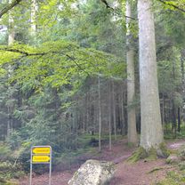
Route quality
Track
51.6 km
(84 %)
Quiet road
5.5 km
(9 %)
Paved
20.3 km
(33 %)
Unpaved
38.1 km
(62 %)
Gravel
29.5 km
(48 %)
Asphalt
9.8 km
(16 %)
Continue with Bikemap
You would like to ride Albtraufmarathon 2009 Mitteldistanz or customize it for your own trip? Here is what you can do with this Bikemap route:
Free trial for 3 days, or one-time payment. More about Bikemap Premium.
Discover more Premium features.
Get Bikemap PremiumFrom our community
Open it in the app