

0904鯵ヶ沢町-青森市-函館市60km
A cycling route starting in Shimokizukuri, Aomori, Japan.
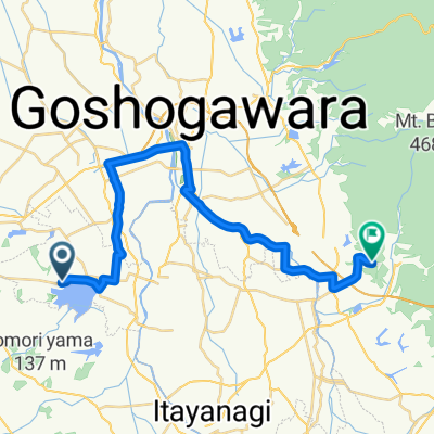
Overview
About this route
岩木山
弘前城 國101-31-150-國101-國7 沙發- -:--
- Duration
- 59.7 km
- Distance
- 338 m
- Ascent
- 380 m
- Descent
- ---
- Avg. speed
- ---
- Max. altitude
Continue with Bikemap
Use, edit, or download this cycling route
You would like to ride 0904鯵ヶ沢町-青森市-函館市60km or customize it for your own trip? Here is what you can do with this Bikemap route:
Free features
- Save this route as favorite or in collections
- Copy & plan your own version of this route
- Sync your route with Garmin or Wahoo
Premium features
Free trial for 3 days, or one-time payment. More about Bikemap Premium.
- Navigate this route on iOS & Android
- Export a GPX / KML file of this route
- Create your custom printout (try it for free)
- Download this route for offline navigation
Discover more Premium features.
Get Bikemap PremiumFrom our community
Other popular routes starting in Shimokizukuri
 rock wood to skyline
- Distance
- 25.3 km
- Ascent
- 1,229 m
- Descent
- 1,626 m
- Location
- Shimokizukuri, Aomori, Japan
 Nakasato Goshogawara Aburakawa Kanita loop
- Distance
- 98.2 km
- Ascent
- 367 m
- Descent
- 370 m
- Location
- Shimokizukuri, Aomori, Japan
 0904鯵ヶ沢町-青森市-函館市60km
- Distance
- 59.7 km
- Ascent
- 338 m
- Descent
- 380 m
- Location
- Shimokizukuri, Aomori, Japan
 Nakasato Ajigasawa Mt Iwaki Hirosaki Kuroishi Lake Towada Mt Hakoda Aomori
- Distance
- 257.2 km
- Ascent
- 2,011 m
- Descent
- 2,011 m
- Location
- Shimokizukuri, Aomori, Japan
 一般県道鶴田五所川原自転車道線(津軽富士見湖狼ノ長根自転車道)
- Distance
- 26.2 km
- Ascent
- 110 m
- Descent
- 36 m
- Location
- Shimokizukuri, Aomori, Japan
 Nakasato Lake Jusan Tappi Zaki Kanita loop
- Distance
- 135 km
- Ascent
- 773 m
- Descent
- 773 m
- Location
- Shimokizukuri, Aomori, Japan
 Nakasato Kuroishi Lake Towada Mt Hakoda Aomori loop
- Distance
- 205.1 km
- Ascent
- 1,695 m
- Descent
- 1,697 m
- Location
- Shimokizukuri, Aomori, Japan
Open it in the app