

Frittentour Teil 2
A cycling route starting in Eckbolsheim, Grand Est, France.
Overview
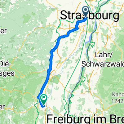
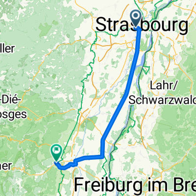
About this route
Strassbourg -Luxembourg-Namur
- -:--
- Duration
- 547.8 km
- Distance
- 1,352 m
- Ascent
- 1,427 m
- Descent
- ---
- Avg. speed
- ---
- Max. altitude

Route quality
Waytypes & surfaces along the route
Waytypes
Cycleway
169.8 km
(31 %)
Quiet road
98.6 km
(18 %)
Surfaces
Paved
465.6 km
(85 %)
Unpaved
21.9 km
(4 %)
Asphalt
367 km
(67 %)
Paved (undefined)
54.8 km
(10 %)
Route highlights
Points of interest along the route
Point of interest after 105.1 km
Association Touristique Camping
Point of interest after 167.6 km
Mawis
Point of interest after 281.2 km
Camping bon accieil
Point of interest after 281.8 km
camping
Point of interest after 381.3 km
Camping de Renval http://www.campingderenval.be
Point of interest after 439.1 km
hhjj
Point of interest after 476.9 km
Camoping le Durnal
Point of interest after 531.4 km
Camping D'alvaux
Continue with Bikemap
Use, edit, or download this cycling route
You would like to ride Frittentour Teil 2 or customize it for your own trip? Here is what you can do with this Bikemap route:
Free features
- Save this route as favorite or in collections
- Copy & plan your own version of this route
- Split it into stages to create a multi-day tour
- Sync your route with Garmin or Wahoo
Premium features
Free trial for 3 days, or one-time payment. More about Bikemap Premium.
- Navigate this route on iOS & Android
- Export a GPX / KML file of this route
- Create your custom printout (try it for free)
- Download this route for offline navigation
Discover more Premium features.
Get Bikemap PremiumFrom our community
Other popular routes starting in Eckbolsheim
 Von Straßburg bis Colmar
- Distance
- 85.4 km
- Ascent
- 401 m
- Descent
- 358 m
- Location
- Eckbolsheim, Grand Est, France
 Von Straßburg bis Türkheim
- Distance
- 81.2 km
- Ascent
- 143 m
- Descent
- 56 m
- Location
- Eckbolsheim, Grand Est, France
 Route to 2 Rue Robert Forrer, 67200 Strasbourg
- Distance
- 12.3 km
- Ascent
- 51 m
- Descent
- 49 m
- Location
- Eckbolsheim, Grand Est, France
 Voie Verte de Brienne-le-Château à Barrière-sur-Seine, Eckbolsheim to Rue du Maréchal Kellermann, Molsheim
- Distance
- 22.1 km
- Ascent
- 42 m
- Descent
- 6 m
- Location
- Eckbolsheim, Grand Est, France
 Strasbourg to Colmar (Passed)
- Distance
- 77.2 km
- Ascent
- 71 m
- Descent
- 26 m
- Location
- Eckbolsheim, Grand Est, France
 2 Rue Henri Bergson, Strasbourg à 1–7 Rue Touchemolin, Strasbourg
- Distance
- 6.5 km
- Ascent
- 158 m
- Descent
- 172 m
- Location
- Eckbolsheim, Grand Est, France
 Pont Pflimlin
- Distance
- 39.4 km
- Ascent
- 136 m
- Descent
- 179 m
- Location
- Eckbolsheim, Grand Est, France
 Day 12: Strasbourg to Rastatt, GR
- Distance
- 62.8 km
- Ascent
- 115 m
- Descent
- 137 m
- Location
- Eckbolsheim, Grand Est, France
Open it in the app