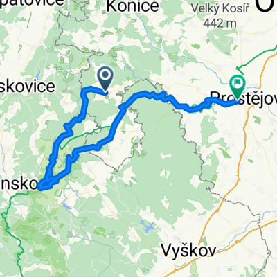
Suchy Trasa I
A cycling route starting in Protivanov, Olomoucký kraj, Czechia.
Overview
About this route
Suchý - RájecnS - DoubravicenS -Boskovice-Suchý
- -:--
- Duration
- 40.3 km
- Distance
- 793 m
- Ascent
- 790 m
- Descent
- ---
- Avg. speed
- ---
- Avg. speed
Route quality
Waytypes & surfaces along the route
Waytypes
Busy road
14.2 km
(35 %)
Road
9.5 km
(24 %)
Surfaces
Paved
13 km
(32 %)
Unpaved
6.5 km
(16 %)
Asphalt
12.7 km
(32 %)
Gravel
3.9 km
(10 %)
Route highlights
Points of interest along the route
Photo after 12.9 km
Zámek Rájec nad Svitavou
Photo after 19.8 km
Hrad Doubravice nS
Photo after 29.6 km
Zámek Boskovice
Photo after 29.9 km
Hrad Boskovice
Continue with Bikemap
Use, edit, or download this cycling route
You would like to ride Suchy Trasa I or customize it for your own trip? Here is what you can do with this Bikemap route:
Free features
- Save this route as favorite or in collections
- Copy & plan your own version of this route
- Sync your route with Garmin or Wahoo
Premium features
Free trial for 3 days, or one-time payment. More about Bikemap Premium.
- Navigate this route on iOS & Android
- Export a GPX / KML file of this route
- Create your custom printout (try it for free)
- Download this route for offline navigation
Discover more Premium features.
Get Bikemap PremiumFrom our community
Other popular routes starting in Protivanov
- Moravský Kras
- Distance
- 45.8 km
- Ascent
- 566 m
- Descent
- 567 m
- Location
- Protivanov, Olomoucký kraj, Czechia
- Protivanov-Vranovice č.4
- Distance
- 63.9 km
- Ascent
- 414 m
- Descent
- 853 m
- Location
- Protivanov, Olomoucký kraj, Czechia
- Suchy Trasa I
- Distance
- 40.3 km
- Ascent
- 793 m
- Descent
- 790 m
- Location
- Protivanov, Olomoucký kraj, Czechia
- EuroVelo: Amber (Baltic Sea to Adriatic Sea)
- Distance
- 1,280.1 km
- Ascent
- 2,084 m
- Descent
- 2,082 m
- Location
- Protivanov, Olomoucký kraj, Czechia
- Suchý Trasa II
- Distance
- 48.2 km
- Ascent
- 660 m
- Descent
- 655 m
- Location
- Protivanov, Olomoucký kraj, Czechia
- 20110424_MH-Buková-MH
- Distance
- 10.3 km
- Ascent
- 188 m
- Descent
- 206 m
- Location
- Protivanov, Olomoucký kraj, Czechia
- 4h zvlneno
- Distance
- 128.1 km
- Ascent
- 1,090 m
- Descent
- 1,089 m
- Location
- Protivanov, Olomoucký kraj, Czechia
- Protivanov dětská
- Distance
- 16.5 km
- Ascent
- 264 m
- Descent
- 261 m
- Location
- Protivanov, Olomoucký kraj, Czechia
Open it in the app