

2015. Csehország
Biciklitúra 2015. 5. nap
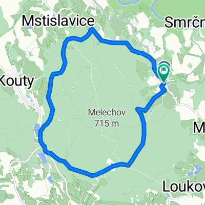
A cycling route starting in Světlá nad Sázavou, Kraj Vysočina, Czechia.
Overview
About this route
- 8 h 8 min
- Duration
- 51.3 km
- Distance
- 404 m
- Ascent
- 387 m
- Descent
- 6.3 km/h
- Avg. speed
- ---
- Max. altitude

Part of
2015. Csehország
6 stages
Route quality
Waytypes & surfaces along the route
Waytypes
Road
23.1 km
(45 %)
Quiet road
13.3 km
(26 %)
Surfaces
Paved
19.5 km
(38 %)
Unpaved
3.6 km
(7 %)
Asphalt
19.5 km
(38 %)
Gravel
2.1 km
(4 %)
Route highlights
Points of interest along the route

Point of interest after 9.5 km

Point of interest after 22.2 km

Point of interest after 22.6 km
pivovar Rebel
Point of interest after 22.7 km
Pivovar Rebel

Point of interest after 42.2 km

Point of interest after 51.3 km
Under construnction
Continue with Bikemap
Use, edit, or download this cycling route
You would like to ride Biciklitúra 2015. 5. nap or customize it for your own trip? Here is what you can do with this Bikemap route:
Free features
- Save this route as favorite or in collections
- Copy & plan your own version of this route
- Sync your route with Garmin or Wahoo
Premium features
Free trial for 3 days, or one-time payment. More about Bikemap Premium.
- Navigate this route on iOS & Android
- Export a GPX / KML file of this route
- Create your custom printout (try it for free)
- Download this route for offline navigation
Discover more Premium features.
Get Bikemap PremiumFrom our community
Other popular routes starting in Světlá nad Sázavou
 Světlá nad Sázavou - Lipnice nad Sázavou - Želiv - Světlá nad Sázavou
- Distance
- 80.4 km
- Ascent
- 1,478 m
- Descent
- 1,478 m
- Location
- Světlá nad Sázavou, Kraj Vysočina, Czechia
 Biciklitúra 2015. 5. nap
- Distance
- 51.3 km
- Ascent
- 404 m
- Descent
- 387 m
- Location
- Světlá nad Sázavou, Kraj Vysočina, Czechia
 Světlá - Horní paseky - Světlá
- Distance
- 28.6 km
- Ascent
- 406 m
- Descent
- 403 m
- Location
- Světlá nad Sázavou, Kraj Vysočina, Czechia
 Smrcna - Lipnice - Humpolec - Kojcice - Sedlice - Melechov - Smrcna
- Distance
- 81.4 km
- Ascent
- 953 m
- Descent
- 952 m
- Location
- Světlá nad Sázavou, Kraj Vysočina, Czechia
 Svetla nad Sazavou - Pelhrimov
- Distance
- 55.9 km
- Ascent
- 653 m
- Descent
- 553 m
- Location
- Světlá nad Sázavou, Kraj Vysočina, Czechia
 Smrcna - Lipnice - Humpolec - Smrcna
- Distance
- 41.8 km
- Ascent
- 727 m
- Descent
- 727 m
- Location
- Světlá nad Sázavou, Kraj Vysočina, Czechia
 Světlá n.S - Habry - Vilémov - Ronov n.D. - Přelouč
- Distance
- 55.5 km
- Ascent
- 446 m
- Descent
- 628 m
- Location
- Světlá nad Sázavou, Kraj Vysočina, Czechia
 Koňkovice-Melechov
- Distance
- 9.7 km
- Ascent
- 274 m
- Descent
- 275 m
- Location
- Světlá nad Sázavou, Kraj Vysočina, Czechia
Open it in the app