
Biciklitúra 2015. 6. nap
A cycling route starting in Dobronín, Kraj Vysočina, Czechia.
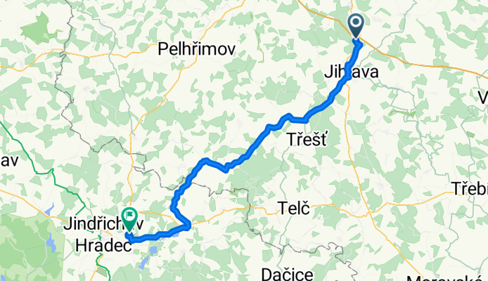
Overview
About this route
- 10 h 37 min
- Duration
- 74.7 km
- Distance
- 594 m
- Ascent
- 602 m
- Descent
- 7 km/h
- Avg. speed
- ---
- Max. altitude

Route quality
Waytypes & surfaces along the route
Waytypes
Road
43.3 km
(58 %)
Quiet road
9.7 km
(13 %)
Surfaces
Paved
29.1 km
(39 %)
Unpaved
1.5 km
(2 %)
Asphalt
29.1 km
(39 %)
Ground
1.5 km
(2 %)
Undefined
44.1 km
(59 %)
Route highlights
Points of interest along the route

Point of interest after 27.7 km

Point of interest after 35.4 km

Point of interest after 39.1 km
Malommúzeum

Point of interest after 45.6 km

Point of interest after 52.4 km

Point of interest after 74.7 km
Camp
Continue with Bikemap
Use, edit, or download this cycling route
You would like to ride Biciklitúra 2015. 6. nap or customize it for your own trip? Here is what you can do with this Bikemap route:
Free features
- Save this route as favorite or in collections
- Copy & plan your own version of this route
- Sync your route with Garmin or Wahoo
Premium features
Free trial for 3 days, or one-time payment. More about Bikemap Premium.
- Navigate this route on iOS & Android
- Export a GPX / KML file of this route
- Create your custom printout (try it for free)
- Download this route for offline navigation
Discover more Premium features.
Get Bikemap PremiumFrom our community
Other popular routes starting in Dobronín
 III.14.7. čtvrtek Jihlava kemp- třebíč
- Distance
- 72.7 km
- Ascent
- 853 m
- Descent
- 967 m
- Location
- Dobronín, Kraj Vysočina, Czechia
 Pávov - Přibyslav - Chotěboř - Trh.Kamenice - Hlinsko - Svratka - Blatiny
- Distance
- 91.2 km
- Ascent
- 783 m
- Descent
- 572 m
- Location
- Dobronín, Kraj Vysočina, Czechia
 Pávov - Věžnička - Polná - Rytířsko - Helenín - Jihlava - Pávov
- Distance
- 40 km
- Ascent
- 389 m
- Descent
- 387 m
- Location
- Dobronín, Kraj Vysočina, Czechia
 Pávovská třicítka
- Distance
- 30.8 km
- Ascent
- 435 m
- Descent
- 432 m
- Location
- Dobronín, Kraj Vysočina, Czechia
 Pávov, Jihlava nach Silnice 38, Želetava
- Distance
- 41.1 km
- Ascent
- 562 m
- Descent
- 495 m
- Location
- Dobronín, Kraj Vysočina, Czechia
 17082011
- Distance
- 39 km
- Ascent
- 286 m
- Descent
- 289 m
- Location
- Dobronín, Kraj Vysočina, Czechia
 Pávov - 40 km Vysočinou
- Distance
- 40.1 km
- Ascent
- 485 m
- Descent
- 482 m
- Location
- Dobronín, Kraj Vysočina, Czechia
 100 km okolo Jihlavy
- Distance
- 105.8 km
- Ascent
- 1,068 m
- Descent
- 1,068 m
- Location
- Dobronín, Kraj Vysočina, Czechia
Open it in the app