

Groniczek, Głowa konia, Filipka, Łączka
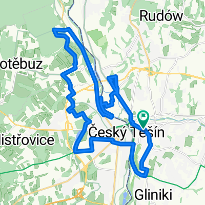
A cycling route starting in Cieszyn, Silesian Voivodeship, Poland.
Overview
About this route
16.07.15
- -:--
- Duration
- 58.8 km
- Distance
- 772 m
- Ascent
- 773 m
- Descent
- ---
- Avg. speed
- ---
- Max. altitude

Route highlights
Points of interest along the route

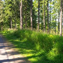
Photo after 0 km
Olza & Puńcówka

Photo after 7.1 km
huta Trzyniec

Photo after 8.6 km
przez Olzę

Photo after 13 km

Photo after 20.6 km
Nawsie, dworzec kolejowy

Photo after 22.9 km
w dolinie potoku Radvanov

Photo after 23.8 km
Wielki Połom, Kozubowa

Photo after 24.4 km
na podjeździe

Photo after 25 km

Photo after 25.3 km

Photo after 27.4 km
stromy odcinek

Photo after 27.4 km
zakręt

Photo after 27.9 km
kolejny zakręt

Point of interest after 28.1 km
Przełęcz Groniczek

Photo after 28.6 km
Przełęcz Jabłonkowska

Point of interest after 28.6 km
Groniczek (837 m n.p.m.) widok na Małą Fatrę

Photo after 28.7 km

Photo after 32.4 km
Przełęcz, Nad Zimnym

Point of interest after 32.4 km
Głowa konia (Konihlava)

Point of interest after 33.1 km
Czupel

Photo after 33.3 km
na szlaku przed Filipką

Photo after 34 km
podjazd na Filipkę

Point of interest after 34.1 km
Filipka 771 m n.p.m.

Point of interest after 35.6 km
Łączka 835 m n.p.n.

Photo after 35.9 km
początek zjazdu

Photo after 51 km
osiedle Trzyniec Borek

Photo after 58 km
Puńcówka & Olza
Continue with Bikemap
Use, edit, or download this cycling route
You would like to ride Groniczek, Głowa konia, Filipka, Łączka or customize it for your own trip? Here is what you can do with this Bikemap route:
Free features
- Save this route as favorite or in collections
- Copy & plan your own version of this route
- Sync your route with Garmin or Wahoo
Premium features
Free trial for 3 days, or one-time payment. More about Bikemap Premium.
- Navigate this route on iOS & Android
- Export a GPX / KML file of this route
- Create your custom printout (try it for free)
- Download this route for offline navigation
Discover more Premium features.
Get Bikemap PremiumFrom our community
Other popular routes starting in Cieszyn
 Kubalonka - inaczej, trudniej !
- Distance
- 88.1 km
- Ascent
- 714 m
- Descent
- 714 m
- Location
- Cieszyn, Silesian Voivodeship, Poland
 Groniczek, Głowa konia, Filipka, Łączka
- Distance
- 58.8 km
- Ascent
- 772 m
- Descent
- 773 m
- Location
- Cieszyn, Silesian Voivodeship, Poland
 Cieszyn-Wielki Połom 1067-cieszyn
- Distance
- 79.6 km
- Ascent
- 859 m
- Descent
- 859 m
- Location
- Cieszyn, Silesian Voivodeship, Poland
 Cieszyn-Dziegielow-Goleszow-Puncow-Cieszyn
- Distance
- 24.3 km
- Ascent
- 271 m
- Descent
- 276 m
- Location
- Cieszyn, Silesian Voivodeship, Poland
 W Dolomity (12 dni) 2002r
- Distance
- 2,273.5 km
- Ascent
- 34,645 m
- Descent
- 34,441 m
- Location
- Cieszyn, Silesian Voivodeship, Poland
 Hrčava
- Distance
- 103.3 km
- Ascent
- 692 m
- Descent
- 691 m
- Location
- Cieszyn, Silesian Voivodeship, Poland
 Cieszyn - Czeski Cieszyn "Bunkry"
- Distance
- 22.3 km
- Ascent
- 172 m
- Descent
- 173 m
- Location
- Cieszyn, Silesian Voivodeship, Poland
 Cieszyn-Tatry-Cieszyn
- Distance
- 371.9 km
- Ascent
- 2,669 m
- Descent
- 2,669 m
- Location
- Cieszyn, Silesian Voivodeship, Poland
Open it in the app