

20150715_132734.gpx
A cycling route starting in Lübberstedt, Lower Saxony, Germany.
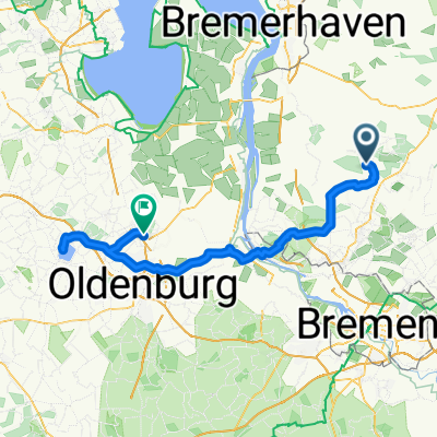
Overview
About this route
TEASI track
- -:--
- Duration
- 49.2 km
- Distance
- 100 m
- Ascent
- 98 m
- Descent
- ---
- Avg. speed
- ---
- Max. altitude
Route quality
Waytypes & surfaces along the route
Waytypes
Quiet road
21.1 km
(43 %)
Track
8.9 km
(18 %)
Surfaces
Paved
27.7 km
(56 %)
Unpaved
10.4 km
(21 %)
Paved (undefined)
15.7 km
(32 %)
Asphalt
10 km
(20 %)
Route highlights
Points of interest along the route
Point of interest after 20.4 km
Weidenweg
Continue with Bikemap
Use, edit, or download this cycling route
You would like to ride 20150715_132734.gpx or customize it for your own trip? Here is what you can do with this Bikemap route:
Free features
- Save this route as favorite or in collections
- Copy & plan your own version of this route
- Sync your route with Garmin or Wahoo
Premium features
Free trial for 3 days, or one-time payment. More about Bikemap Premium.
- Navigate this route on iOS & Android
- Export a GPX / KML file of this route
- Create your custom printout (try it for free)
- Download this route for offline navigation
Discover more Premium features.
Get Bikemap PremiumFrom our community
Other popular routes starting in Lübberstedt
 Zeitung Oldendorf
- Distance
- 10.4 km
- Ascent
- 21 m
- Descent
- 24 m
- Location
- Lübberstedt, Lower Saxony, Germany
 20150715_132734.gpx
- Distance
- 49.2 km
- Ascent
- 100 m
- Descent
- 98 m
- Location
- Lübberstedt, Lower Saxony, Germany
 Meyenburg Aschwarden
- Distance
- 70.6 km
- Ascent
- 90 m
- Descent
- 88 m
- Location
- Lübberstedt, Lower Saxony, Germany
 Lübbs-Wowe_3
- Distance
- 55 km
- Ascent
- 193 m
- Descent
- 209 m
- Location
- Lübberstedt, Lower Saxony, Germany
 Melchers
- Distance
- 39.5 km
- Ascent
- 100 m
- Descent
- 108 m
- Location
- Lübberstedt, Lower Saxony, Germany
 Rund um die Mühle
- Distance
- 3.7 km
- Ascent
- 9 m
- Descent
- 9 m
- Location
- Lübberstedt, Lower Saxony, Germany
 Schulstraße nach Oldenburger Straße
- Distance
- 97.1 km
- Ascent
- 186 m
- Descent
- 184 m
- Location
- Lübberstedt, Lower Saxony, Germany
 Melchers
- Distance
- 37 km
- Ascent
- 81 m
- Descent
- 80 m
- Location
- Lübberstedt, Lower Saxony, Germany
Open it in the app