
20150708_182143.gpx
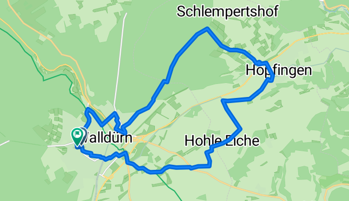
A cycling route starting in Walldürn, Baden-Wurttemberg, Germany.
Overview
About this route
TEASI track
- -:--
- Duration
- 18.3 km
- Distance
- 217 m
- Ascent
- 219 m
- Descent
- ---
- Avg. speed
- ---
- Max. altitude
Route quality
Waytypes & surfaces along the route
Waytypes
Quiet road
8.4 km
(46 %)
Track
7.7 km
(42 %)
Surfaces
Paved
10.1 km
(55 %)
Unpaved
2.8 km
(15 %)
Asphalt
8.1 km
(44 %)
Paved (undefined)
2 km
(11 %)
Continue with Bikemap
Use, edit, or download this cycling route
You would like to ride 20150708_182143.gpx or customize it for your own trip? Here is what you can do with this Bikemap route:
Free features
- Save this route as favorite or in collections
- Copy & plan your own version of this route
- Sync your route with Garmin or Wahoo
Premium features
Free trial for 3 days, or one-time payment. More about Bikemap Premium.
- Navigate this route on iOS & Android
- Export a GPX / KML file of this route
- Create your custom printout (try it for free)
- Download this route for offline navigation
Discover more Premium features.
Get Bikemap PremiumFrom our community
Other popular routes starting in Walldürn
 Grünkernradweg - Route 1
- Distance
- 50.4 km
- Ascent
- 354 m
- Descent
- 529 m
- Location
- Walldürn, Baden-Wurttemberg, Germany
 Grünkernradweg ab Walldürn
- Distance
- 78.5 km
- Ascent
- 759 m
- Descent
- 758 m
- Location
- Walldürn, Baden-Wurttemberg, Germany
 Südlicher Jakobsweg
- Distance
- 2,573.4 km
- Ascent
- 3,063 m
- Descent
- 3,171 m
- Location
- Walldürn, Baden-Wurttemberg, Germany
 Walldürn-Buchen-Schneeberg-Walldürn
- Distance
- 37 km
- Ascent
- 700 m
- Descent
- 706 m
- Location
- Walldürn, Baden-Wurttemberg, Germany
 Baden - Bauland - Bayern
- Distance
- 106.1 km
- Ascent
- 1,075 m
- Descent
- 1,118 m
- Location
- Walldürn, Baden-Wurttemberg, Germany
 walldürn - kloster schöntal
- Distance
- 36 km
- Ascent
- 338 m
- Descent
- 517 m
- Location
- Walldürn, Baden-Wurttemberg, Germany
 Tag 3 2019 Walldürn/Dettelbach
- Distance
- 91.2 km
- Ascent
- 374 m
- Descent
- 594 m
- Location
- Walldürn, Baden-Wurttemberg, Germany
 Walldürn - Rothenburg ob der Tauber
- Distance
- 157.7 km
- Ascent
- 441 m
- Descent
- 438 m
- Location
- Walldürn, Baden-Wurttemberg, Germany
Open it in the app