
20150718_171045.gpx
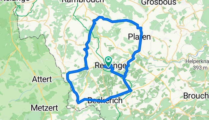
A cycling route starting in Redange, District de Diekirch, Luxembourg.
Overview
About this route
TEASI track (cloned from route 3158506)
(cloned from route 3158562)
- -:--
- Duration
- 39.1 km
- Distance
- 356 m
- Ascent
- 356 m
- Descent
- ---
- Avg. speed
- ---
- Max. altitude
Route quality
Waytypes & surfaces along the route
Waytypes
Quiet road
1.6 km
(4 %)
Path
1.2 km
(3 %)
Undefined
36.4 km
(93 %)
Surfaces
Paved
38.7 km
(99 %)
Asphalt
38.7 km
(99 %)
Undefined
0.4 km
(1 %)
Continue with Bikemap
Use, edit, or download this cycling route
You would like to ride 20150718_171045.gpx or customize it for your own trip? Here is what you can do with this Bikemap route:
Free features
- Save this route as favorite or in collections
- Copy & plan your own version of this route
- Sync your route with Garmin or Wahoo
Premium features
Free trial for 3 days, or one-time payment. More about Bikemap Premium.
- Navigate this route on iOS & Android
- Export a GPX / KML file of this route
- Create your custom printout (try it for free)
- Download this route for offline navigation
Discover more Premium features.
Get Bikemap PremiumFrom our community
Other popular routes starting in Redange
 Rue de Reichlange 2, Redingen nach Rue Kiem 2, Bartringen
- Distance
- 30 km
- Ascent
- 734 m
- Descent
- 665 m
- Location
- Redange, District de Diekirch, Luxembourg
 80k heinerscheid
- Distance
- 79.7 km
- Ascent
- 683 m
- Descent
- 683 m
- Location
- Redange, District de Diekirch, Luxembourg
 Redange Attert - Luxembourg
- Distance
- 37 km
- Ascent
- 238 m
- Descent
- 278 m
- Location
- Redange, District de Diekirch, Luxembourg
 Route 24,7km
- Distance
- 24.8 km
- Ascent
- 307 m
- Descent
- 309 m
- Location
- Redange, District de Diekirch, Luxembourg
 Redange-Ketzin
- Distance
- 742.3 km
- Ascent
- 922 m
- Descent
- 1,223 m
- Location
- Redange, District de Diekirch, Luxembourg
 20150718_171045.gpx
- Distance
- 39.1 km
- Ascent
- 348 m
- Descent
- 348 m
- Location
- Redange, District de Diekirch, Luxembourg
 20150718_171045.gpx
- Distance
- 39.1 km
- Ascent
- 356 m
- Descent
- 356 m
- Location
- Redange, District de Diekirch, Luxembourg
 Route 27,8km
- Distance
- 27.9 km
- Ascent
- 291 m
- Descent
- 294 m
- Location
- Redange, District de Diekirch, Luxembourg
Open it in the app