

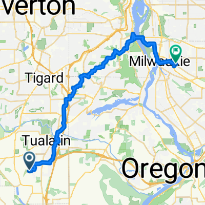
24km + Route
A cycling route starting in Tualatin, Oregon, United States.
Overview
About this route
Mostly country, some roads have a bit of traffic
- -:--
- Duration
- 24.8 km
- Distance
- 221 m
- Ascent
- 221 m
- Descent
- ---
- Avg. speed
- ---
- Max. altitude
Continue with Bikemap
Use, edit, or download this cycling route
You would like to ride 24km + Route or customize it for your own trip? Here is what you can do with this Bikemap route:
Free features
- Save this route as favorite or in collections
- Copy & plan your own version of this route
- Sync your route with Garmin or Wahoo
Premium features
Free trial for 3 days, or one-time payment. More about Bikemap Premium.
- Navigate this route on iOS & Android
- Export a GPX / KML file of this route
- Create your custom printout (try it for free)
- Download this route for offline navigation
Discover more Premium features.
Get Bikemap PremiumFrom our community
Other popular routes starting in Tualatin
 MP martinazzi-stafford road
- Distance
- 18.3 km
- Ascent
- 130 m
- Descent
- 130 m
- Location
- Tualatin, Oregon, United States
 SW Sweek Dr, Tualatin to SW Sweek Dr, Tualatin
- Distance
- 10.2 km
- Ascent
- 39 m
- Descent
- 43 m
- Location
- Tualatin, Oregon, United States
 Ibach Park to Tile Flat Rd
- Distance
- 55.3 km
- Ascent
- 266 m
- Descent
- 272 m
- Location
- Tualatin, Oregon, United States
 Tualatin to Downtown Portland
- Distance
- 29.7 km
- Ascent
- 288 m
- Descent
- 268 m
- Location
- Tualatin, Oregon, United States
 SW 110th Pl, Tualatin to SE Rio Vista St, Milwaukie
- Distance
- 28.6 km
- Ascent
- 418 m
- Descent
- 487 m
- Location
- Tualatin, Oregon, United States
 Ibach & back
- Distance
- 6 km
- Ascent
- 73 m
- Descent
- 76 m
- Location
- Tualatin, Oregon, United States
 Walk with Jan in Tualatin
- Distance
- 11.9 km
- Ascent
- 71 m
- Descent
- 67 m
- Location
- Tualatin, Oregon, United States
 Tualatin River
- Distance
- 37.6 km
- Ascent
- 341 m
- Descent
- 339 m
- Location
- Tualatin, Oregon, United States
Open it in the app