
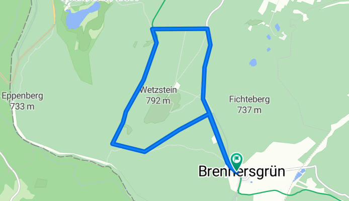
kurze Wetzsteinumrundung
A cycling route starting in Reichenbach, Bavaria, Germany.
Overview
About this route
The route goes over Stern, Rondell, Wetzstein parking lot and back through the street to Brennersgrün.
- -:--
- Duration
- 7.9 km
- Distance
- 63 m
- Ascent
- 59 m
- Descent
- ---
- Avg. speed
- 757 m
- Max. altitude

Route quality
Waytypes & surfaces along the route
Waytypes
Track
4.5 km
(57 %)
Road
3.4 km
(43 %)
Surfaces
Paved
3.4 km
(43 %)
Unpaved
4.5 km
(57 %)
Gravel
4.5 km
(57 %)
Asphalt
3.4 km
(43 %)
Continue with Bikemap
Use, edit, or download this cycling route
You would like to ride kurze Wetzsteinumrundung or customize it for your own trip? Here is what you can do with this Bikemap route:
Free features
- Save this route as favorite or in collections
- Copy & plan your own version of this route
- Sync your route with Garmin or Wahoo
Premium features
Free trial for 3 days, or one-time payment. More about Bikemap Premium.
- Navigate this route on iOS & Android
- Export a GPX / KML file of this route
- Create your custom printout (try it for free)
- Download this route for offline navigation
Discover more Premium features.
Get Bikemap PremiumFrom our community
Other popular routes starting in Reichenbach
 2024-06-11 Steinbach am Wald nach Coburg
- Distance
- 58 km
- Ascent
- 514 m
- Descent
- 812 m
- Location
- Reichenbach, Bavaria, Germany
 Ortsrundfahrt
- Distance
- 17.5 km
- Ascent
- 305 m
- Descent
- 332 m
- Location
- Reichenbach, Bavaria, Germany
 2024-06-07 Route nach Otto-Wiegand-Straße 7, 96361 Steinbach am Wald
- Distance
- 32.5 km
- Ascent
- 516 m
- Descent
- 516 m
- Location
- Reichenbach, Bavaria, Germany
 Stb/W - Leibis - Schwarzatal - SLF- Ltnbg
- Distance
- 78.3 km
- Ascent
- 1,133 m
- Descent
- 1,419 m
- Location
- Reichenbach, Bavaria, Germany
 Frankenwald MTB Nr. 3
- Distance
- 55 km
- Ascent
- 1,134 m
- Descent
- 1,170 m
- Location
- Reichenbach, Bavaria, Germany
 Reichenbach - Staatsbruch - Reichenbach
- Distance
- 12.7 km
- Ascent
- 217 m
- Descent
- 214 m
- Location
- Reichenbach, Bavaria, Germany
 Tour nach Lehesten
- Distance
- 14.8 km
- Ascent
- 194 m
- Descent
- 162 m
- Location
- Reichenbach, Bavaria, Germany
 Frankenwald 47km 1040hm
- Distance
- 46.4 km
- Ascent
- 1,000 m
- Descent
- 999 m
- Location
- Reichenbach, Bavaria, Germany
Open it in the app