

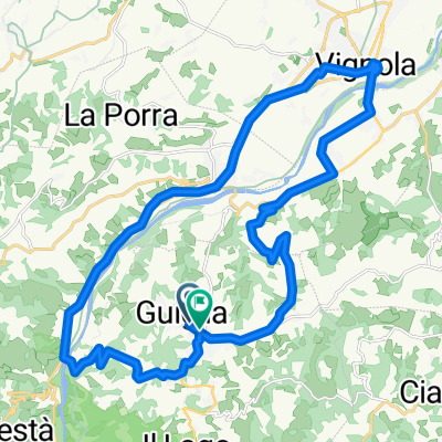
20150718_160743.gpx
A cycling route starting in Guiglia, Emilia-Romagna, Italy.
Overview
About this route
TEASI track
- -:--
- Duration
- 7.6 km
- Distance
- 26 m
- Ascent
- 335 m
- Descent
- ---
- Avg. speed
- ---
- Max. altitude
Route quality
Waytypes & surfaces along the route
Waytypes
Road
4.5 km
(59 %)
Busy road
1.1 km
(15 %)
Surfaces
Paved
4 km
(52 %)
Unpaved
1.1 km
(15 %)
Asphalt
4 km
(52 %)
Gravel
1.1 km
(15 %)
Undefined
2.5 km
(33 %)
Continue with Bikemap
Use, edit, or download this cycling route
You would like to ride 20150718_160743.gpx or customize it for your own trip? Here is what you can do with this Bikemap route:
Free features
- Save this route as favorite or in collections
- Copy & plan your own version of this route
- Sync your route with Garmin or Wahoo
Premium features
Free trial for 3 days, or one-time payment. More about Bikemap Premium.
- Navigate this route on iOS & Android
- Export a GPX / KML file of this route
- Create your custom printout (try it for free)
- Download this route for offline navigation
Discover more Premium features.
Get Bikemap PremiumFrom our community
Other popular routes starting in Guiglia
 Festà - Ponte Sestaione
- Distance
- 70.2 km
- Ascent
- 1,855 m
- Descent
- 1,427 m
- Location
- Guiglia, Emilia-Romagna, Italy
 sassi - monte della riva
- Distance
- 33.6 km
- Ascent
- 693 m
- Descent
- 691 m
- Location
- Guiglia, Emilia-Romagna, Italy
 MO_XXX_Casona_anelloSassiRoccamalatina
- Distance
- 25.2 km
- Ascent
- 526 m
- Descent
- 526 m
- Location
- Guiglia, Emilia-Romagna, Italy
 rondje guiglia
- Distance
- 29.1 km
- Ascent
- 402 m
- Descent
- 410 m
- Location
- Guiglia, Emilia-Romagna, Italy
 Percorso rilassato in Marano sul Panaro
- Distance
- 17 km
- Ascent
- 206 m
- Descent
- 236 m
- Location
- Guiglia, Emilia-Romagna, Italy
 sassi roccamalatina
- Distance
- 22 km
- Ascent
- 595 m
- Descent
- 596 m
- Location
- Guiglia, Emilia-Romagna, Italy
 Sassi di Roccamalatina e Ponticelli
- Distance
- 33.2 km
- Ascent
- 738 m
- Descent
- 738 m
- Location
- Guiglia, Emilia-Romagna, Italy
 d) Ciclovia Parco dei Sassi di Roccamalatina
- Distance
- 24.9 km
- Ascent
- 756 m
- Descent
- 613 m
- Location
- Guiglia, Emilia-Romagna, Italy
Open it in the app