

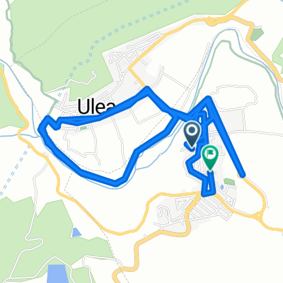
VII Quedada Cross El Mayés 2016
A cycling route starting in Ulea, Murcia, Spain.
Overview
About this route
The route consists of about 30 kilometers of medium/low difficulty, where we will climb the Cajal path and descend it to the Mayés dam, from there we will reach the starting point again by road.
- -:--
- Duration
- 33.1 km
- Distance
- 603 m
- Ascent
- 603 m
- Descent
- ---
- Avg. speed
- ---
- Max. altitude

Route quality
Waytypes & surfaces along the route
Waytypes
Track
16.2 km
(49 %)
Quiet road
10.3 km
(31 %)
Surfaces
Paved
15.6 km
(47 %)
Unpaved
8.3 km
(25 %)
Asphalt
15.6 km
(47 %)
Gravel
7.9 km
(24 %)
Continue with Bikemap
Use, edit, or download this cycling route
You would like to ride VII Quedada Cross El Mayés 2016 or customize it for your own trip? Here is what you can do with this Bikemap route:
Free features
- Save this route as favorite or in collections
- Copy & plan your own version of this route
- Sync your route with Garmin or Wahoo
Premium features
Free trial for 3 days, or one-time payment. More about Bikemap Premium.
- Navigate this route on iOS & Android
- Export a GPX / KML file of this route
- Create your custom printout (try it for free)
- Download this route for offline navigation
Discover more Premium features.
Get Bikemap PremiumFrom our community
Other popular routes starting in Ulea
 sierra ricote x cajal, y sierra de la pila
- Distance
- 91.6 km
- Ascent
- 1,835 m
- Descent
- 1,836 m
- Location
- Ulea, Murcia, Spain
 VII Quedada Cross El Mayés 2016
- Distance
- 33.1 km
- Ascent
- 603 m
- Descent
- 603 m
- Location
- Ulea, Murcia, Spain
 De Calle Gambines a Calle Gambines
- Distance
- 13 km
- Ascent
- 106 m
- Descent
- 143 m
- Location
- Ulea, Murcia, Spain
 Villanueva - Valle de Ricote
- Distance
- 40.3 km
- Ascent
- 923 m
- Descent
- 920 m
- Location
- Ulea, Murcia, Spain
 ruta x sierra ricote, vuelta carretera cajal bajada por rambLA
- Distance
- 73.9 km
- Ascent
- 1,237 m
- Descent
- 1,237 m
- Location
- Ulea, Murcia, Spain
 De Calle Gambines a Avenida Juan Carlos I
- Distance
- 47 km
- Ascent
- 898 m
- Descent
- 841 m
- Location
- Ulea, Murcia, Spain
 ulea charcas de caputa enbalse de la cierva
- Distance
- 76.6 km
- Ascent
- 1,209 m
- Descent
- 1,209 m
- Location
- Ulea, Murcia, Spain
 bike tour through Ulea
- Distance
- 22.9 km
- Ascent
- 221 m
- Descent
- 221 m
- Location
- Ulea, Murcia, Spain
Open it in the app