

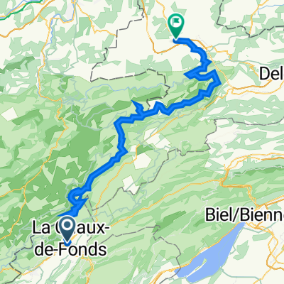
Le Chaux-de-Fonds-Pré Petitjean
A cycling route starting in La Chaux-de-Fonds, Canton of Neuchâtel, Switzerland.
Overview
About this route
In cold 17 degrees and rain across the mountains. Abandoned in Pre Petitjean due to heavy rain. The tour was originally planned until Glovelier.
- -:--
- Duration
- 50.6 km
- Distance
- 813 m
- Ascent
- 819 m
- Descent
- ---
- Avg. speed
- 1,104 m
- Max. altitude

Route quality
Waytypes & surfaces along the route
Waytypes
Quiet road
24.8 km
(49 %)
Access road
1.5 km
(3 %)
Surfaces
Paved
22.3 km
(44 %)
Asphalt
16.2 km
(32 %)
Paved (undefined)
6.1 km
(12 %)
Undefined
28.3 km
(56 %)
Route highlights
Points of interest along the route

Point of interest after 9.1 km
Nichts als Pferde und Ruhe!

Point of interest after 36.8 km
Jura und seine Weggrenzen

Point of interest after 50.5 km
Am Ende und dem endlosen Regen habe ich noch etwas ganz besonderes gefunden: Traditionsbahn der CJ
Continue with Bikemap
Use, edit, or download this cycling route
You would like to ride Le Chaux-de-Fonds-Pré Petitjean or customize it for your own trip? Here is what you can do with this Bikemap route:
Free features
- Save this route as favorite or in collections
- Copy & plan your own version of this route
- Sync your route with Garmin or Wahoo
Premium features
Free trial for 3 days, or one-time payment. More about Bikemap Premium.
- Navigate this route on iOS & Android
- Export a GPX / KML file of this route
- Create your custom printout (try it for free)
- Download this route for offline navigation
Discover more Premium features.
Get Bikemap PremiumFrom our community
Other popular routes starting in La Chaux-de-Fonds
 Doubs Rundtour Juni 2023
- Distance
- 152.2 km
- Ascent
- 3,637 m
- Descent
- 3,638 m
- Location
- La Chaux-de-Fonds, Canton of Neuchâtel, Switzerland
 VTT Pouillerel 16Km (1h30)
- Distance
- 16.1 km
- Ascent
- 326 m
- Descent
- 327 m
- Location
- La Chaux-de-Fonds, Canton of Neuchâtel, Switzerland
 Doubs
Doubs- Distance
- 38 km
- Ascent
- 871 m
- Descent
- 871 m
- Location
- La Chaux-de-Fonds, Canton of Neuchâtel, Switzerland
 La Chaux-des-Fonds nach Porountruy
- Distance
- 86.9 km
- Ascent
- 1,912 m
- Descent
- 2,482 m
- Location
- La Chaux-de-Fonds, Canton of Neuchâtel, Switzerland
 petite tour du matin
- Distance
- 30.7 km
- Ascent
- 1,163 m
- Descent
- 1,156 m
- Location
- La Chaux-de-Fonds, Canton of Neuchâtel, Switzerland
 la Ferrière
- Distance
- 28.7 km
- Ascent
- 519 m
- Descent
- 515 m
- Location
- La Chaux-de-Fonds, Canton of Neuchâtel, Switzerland
 La Chaux-de-Fonds - St Croix
- Distance
- 111.5 km
- Ascent
- 1,316 m
- Descent
- 1,316 m
- Location
- La Chaux-de-Fonds, Canton of Neuchâtel, Switzerland
 La Chaux-de-Fonds - Tête-de-Ran
- Distance
- 19.5 km
- Ascent
- 597 m
- Descent
- 597 m
- Location
- La Chaux-de-Fonds, Canton of Neuchâtel, Switzerland
Open it in the app