

speed maus
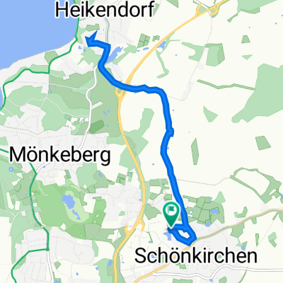
A cycling route starting in Schönkirchen, Schleswig-Holstein, Germany.
Overview
About this route
Especially to enjoy at sunset.
- -:--
- Duration
- 37.4 km
- Distance
- 148 m
- Ascent
- 148 m
- Descent
- ---
- Avg. speed
- ---
- Max. altitude
Route quality
Waytypes & surfaces along the route
Waytypes
Quiet road
14.6 km
(39 %)
Path
11.2 km
(30 %)
Surfaces
Paved
28.8 km
(77 %)
Asphalt
27.7 km
(74 %)
Paved (undefined)
1.1 km
(3 %)
Undefined
8.6 km
(23 %)
Continue with Bikemap
Use, edit, or download this cycling route
You would like to ride speed maus or customize it for your own trip? Here is what you can do with this Bikemap route:
Free features
- Save this route as favorite or in collections
- Copy & plan your own version of this route
- Sync your route with Garmin or Wahoo
Premium features
Free trial for 3 days, or one-time payment. More about Bikemap Premium.
- Navigate this route on iOS & Android
- Export a GPX / KML file of this route
- Create your custom printout (try it for free)
- Download this route for offline navigation
Discover more Premium features.
Get Bikemap PremiumFrom our community
Other popular routes starting in Schönkirchen
 Schönkirchen-Hessenstein-Schönberg-Schönkirchen
- Distance
- 89.7 km
- Ascent
- 349 m
- Descent
- 342 m
- Location
- Schönkirchen, Schleswig-Holstein, Germany
 Wasser und schöne Landschaft
- Distance
- 14.7 km
- Ascent
- 84 m
- Descent
- 87 m
- Location
- Schönkirchen, Schleswig-Holstein, Germany
 Schöne Runde an der Förde und durch die Probstei
- Distance
- 28.7 km
- Ascent
- 128 m
- Descent
- 143 m
- Location
- Schönkirchen, Schleswig-Holstein, Germany
 Maritim-Route der Probstei mit Rad
- Distance
- 68.2 km
- Ascent
- 312 m
- Descent
- 317 m
- Location
- Schönkirchen, Schleswig-Holstein, Germany
 Langsame Fahrt in Schönkirchen
- Distance
- 13.7 km
- Ascent
- 9 m
- Descent
- 33 m
- Location
- Schönkirchen, Schleswig-Holstein, Germany
 Probstei mit viel Wasser
- Distance
- 25.7 km
- Ascent
- 76 m
- Descent
- 76 m
- Location
- Schönkirchen, Schleswig-Holstein, Germany
 Probstei-Tour
- Distance
- 47.6 km
- Ascent
- 94 m
- Descent
- 94 m
- Location
- Schönkirchen, Schleswig-Holstein, Germany
 Schönkirchen - Ingo
- Distance
- 8.5 km
- Ascent
- 64 m
- Descent
- 65 m
- Location
- Schönkirchen, Schleswig-Holstein, Germany
Open it in the app