

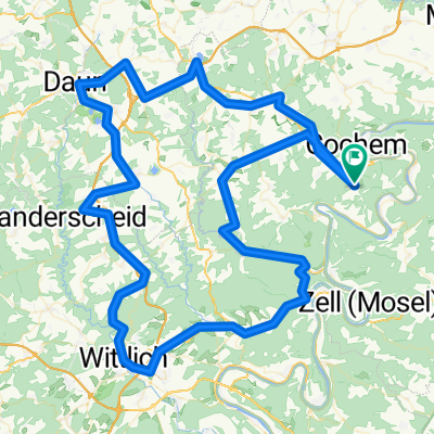
Roompot Cochem - Cochem - Landskern
A cycling route starting in Ediger-Eller, Rhineland-Palatinate, Germany.
Overview
About this route
From Cochem to Landskern and then in direction of Laubach - from 100 to roughly 550 meters. On return short steep climb after descent of 20%
- -:--
- Duration
- 37 km
- Distance
- 647 m
- Ascent
- 646 m
- Descent
- ---
- Avg. speed
- ---
- Max. altitude
Route quality
Waytypes & surfaces along the route
Waytypes
Road
6.3 km
(17 %)
Track
3.3 km
(9 %)
Surfaces
Paved
36.3 km
(98 %)
Unpaved
0.7 km
(2 %)
Asphalt
35.6 km
(96 %)
Paved (undefined)
0.7 km
(2 %)
Continue with Bikemap
Use, edit, or download this cycling route
You would like to ride Roompot Cochem - Cochem - Landskern or customize it for your own trip? Here is what you can do with this Bikemap route:
Free features
- Save this route as favorite or in collections
- Copy & plan your own version of this route
- Sync your route with Garmin or Wahoo
Premium features
Free trial for 3 days, or one-time payment. More about Bikemap Premium.
- Navigate this route on iOS & Android
- Export a GPX / KML file of this route
- Create your custom printout (try it for free)
- Download this route for offline navigation
Discover more Premium features.
Get Bikemap PremiumFrom our community
Other popular routes starting in Ediger-Eller
 Cochem - Zell - Cochem
- Distance
- 65.3 km
- Ascent
- 1,201 m
- Descent
- 1,202 m
- Location
- Ediger-Eller, Rhineland-Palatinate, Germany
 August 12 2015: climb Bremm form Cochem Roompot
- Distance
- 40.7 km
- Ascent
- 505 m
- Descent
- 502 m
- Location
- Ediger-Eller, Rhineland-Palatinate, Germany
 August 8 2015: valwig klotten roompot
- Distance
- 39 km
- Ascent
- 860 m
- Descent
- 857 m
- Location
- Ediger-Eller, Rhineland-Palatinate, Germany
 Roompot-Burcht vv
- Distance
- 10.7 km
- Ascent
- 419 m
- Descent
- 417 m
- Location
- Ediger-Eller, Rhineland-Palatinate, Germany
 Runde durch die Eifel Start/Ziel Golfresort
- Distance
- 130.9 km
- Ascent
- 805 m
- Descent
- 805 m
- Location
- Ediger-Eller, Rhineland-Palatinate, Germany
 Roompot Cochem - Valwigerberg - Stadtwald
- Distance
- 26.7 km
- Ascent
- 618 m
- Descent
- 619 m
- Location
- Ediger-Eller, Rhineland-Palatinate, Germany
 moesel
- Distance
- 59.9 km
- Ascent
- 750 m
- Descent
- 750 m
- Location
- Ediger-Eller, Rhineland-Palatinate, Germany
 Rondje Moezel
- Distance
- 42.5 km
- Ascent
- 1,237 m
- Descent
- 1,243 m
- Location
- Ediger-Eller, Rhineland-Palatinate, Germany
Open it in the app