
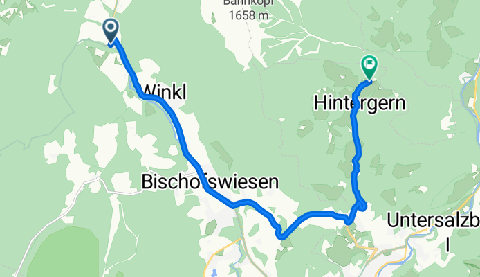
Hintergern, Maria Gern
A cycling route starting in Bischofswiesen, Bavaria, Germany.
Overview
About this route
sssssssssssssssssssss
- -:--
- Duration
- 11.2 km
- Distance
- 251 m
- Ascent
- 104 m
- Descent
- ---
- Avg. speed
- ---
- Max. altitude
Route quality
Waytypes & surfaces along the route
Waytypes
Path
3.3 km
(29 %)
Road
2.9 km
(26 %)
Surfaces
Paved
10.3 km
(92 %)
Asphalt
10.3 km
(92 %)
Undefined
0.9 km
(8 %)
Continue with Bikemap
Use, edit, or download this cycling route
You would like to ride Hintergern, Maria Gern or customize it for your own trip? Here is what you can do with this Bikemap route:
Free features
- Save this route as favorite or in collections
- Copy & plan your own version of this route
- Sync your route with Garmin or Wahoo
Premium features
Free trial for 3 days, or one-time payment. More about Bikemap Premium.
- Navigate this route on iOS & Android
- Export a GPX / KML file of this route
- Create your custom printout (try it for free)
- Download this route for offline navigation
Discover more Premium features.
Get Bikemap PremiumFrom our community
Other popular routes starting in Bischofswiesen
 Gotzenalm
- Distance
- 40.4 km
- Ascent
- 1,541 m
- Descent
- 1,541 m
- Location
- Bischofswiesen, Bavaria, Germany
 Rund um den Untersberg
- Distance
- 54.3 km
- Ascent
- 681 m
- Descent
- 682 m
- Location
- Bischofswiesen, Bavaria, Germany
 Der Obersalzberg in Berchtesgaden
- Distance
- 28.1 km
- Ascent
- 587 m
- Descent
- 588 m
- Location
- Bischofswiesen, Bavaria, Germany
 MTB Runde mit Trimm-dich-Pfad u.Trail
- Distance
- 12.7 km
- Ascent
- 211 m
- Descent
- 209 m
- Location
- Bischofswiesen, Bavaria, Germany
 Berchtesgaden - Lockstein - Kälbersteinschanze und -kapelle - Kastensteinerwand Alm
- Distance
- 29.8 km
- Ascent
- 620 m
- Descent
- 610 m
- Location
- Bischofswiesen, Bavaria, Germany
 Zeltplatz Winkl-Rund um den Untersberg CLONED FROM ROUTE 790781
- Distance
- 40.5 km
- Ascent
- 450 m
- Descent
- 450 m
- Location
- Bischofswiesen, Bavaria, Germany
 EU22 Day 5 Bischofswiesen #1
- Distance
- 12.4 km
- Ascent
- 108 m
- Descent
- 95 m
- Location
- Bischofswiesen, Bavaria, Germany
 Biergartenrunde zum Königssee...
- Distance
- 34.4 km
- Ascent
- 313 m
- Descent
- 303 m
- Location
- Bischofswiesen, Bavaria, Germany
Open it in the app