

Lohr-Maintal-Platte
A cycling route starting in Lohr a. Main, Bavaria, Germany.
Overview
About this route
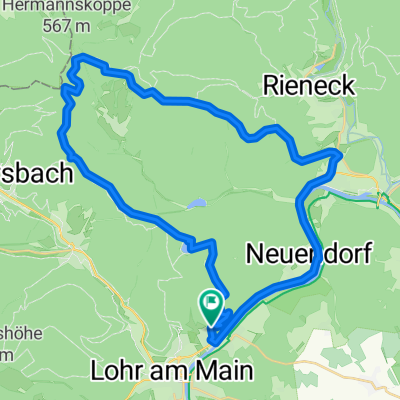
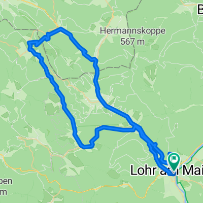
Start and endpoint is located in the Sendelbach district of Lohr. First, we roll out to Pflochsbach, optionally on the road or bike path. For the road bike, I recommend switching to the road just before Pflochsbach, although the bike path running right along the river to Erlach works too. From Erlach to Zimmern, the route remains flat. At the end of Zimmern, we head towards Urspringen into the first incline, just right after warming up for about 30 minutes. This is the most moderate ascent to the "Platte," thus a paradise for road cyclists. Nicely rolling with not-too-long climbs and gentle descents where one can pedal well. Thus flows the way to Urspringen. There, from the center of the village, we climb the hill and then speed along the long rolling straight at the edge of the forest heading towards Steinfeld. From there, it remains mostly flat through fields back towards Lohr, into the Buchental valley. From the Buchenmühle we enter the forest and the road climbs slightly. From the turnoff to the pilgrimage church of Maria Buchen, it goes downhill. The highlight is the rapid 10% descent to the Sendelbacher sports field and back to the starting point.
The section before Roden to Urspringen is not really recommended for midday in midsummer, as it goes across the field. Depending on your mood, this "base loop" can be shortened (before Roden to Ansbach and down the Waldzeller Berg into the Main valley) or extended (Urspringen via Stadelhofen or Duttenbrunn and possibly from there into the Main valley towards Zellingen or Karlstadt and back along the Main).
I really like this route, as you are nicely warmed up before the moderate ascent to the road cyclist's paradise "Platte" and because you can adjust the route according to your mood, fitness or available time.
- -:--
- Duration
- 33.4 km
- Distance
- 345 m
- Ascent
- 246 m
- Descent
- ---
- Avg. speed
- 315 m
- Max. altitude

Route quality
Waytypes & surfaces along the route
Waytypes
Road
15 km
(45 %)
Quiet road
3.3 km
(10 %)
Surfaces
Paved
13.7 km
(41 %)
Unpaved
0.7 km
(2 %)
Asphalt
13.7 km
(41 %)
Gravel
0.3 km
(1 %)
Continue with Bikemap
Use, edit, or download this cycling route
You would like to ride Lohr-Maintal-Platte or customize it for your own trip? Here is what you can do with this Bikemap route:
Free features
- Save this route as favorite or in collections
- Copy & plan your own version of this route
- Sync your route with Garmin or Wahoo
Premium features
Free trial for 3 days, or one-time payment. More about Bikemap Premium.
- Navigate this route on iOS & Android
- Export a GPX / KML file of this route
- Create your custom printout (try it for free)
- Download this route for offline navigation
Discover more Premium features.
Get Bikemap PremiumFrom our community
Other popular routes starting in Lohr a. Main
 Lohr-Maintal-Platte
- Distance
- 33.4 km
- Ascent
- 345 m
- Descent
- 246 m
- Location
- Lohr a. Main, Bavaria, Germany
 1ter Tag alternative
- Distance
- 41.6 km
- Ascent
- 531 m
- Descent
- 480 m
- Location
- Lohr a. Main, Bavaria, Germany
 The Fog
- Distance
- 41 km
- Ascent
- 683 m
- Descent
- 683 m
- Location
- Lohr a. Main, Bavaria, Germany
 Von Lohr am Main bis Frammersbacher Forst
- Distance
- 60.5 km
- Ascent
- 1,048 m
- Descent
- 1,046 m
- Location
- Lohr a. Main, Bavaria, Germany
 Ausfahrt durch Lohr am Main
- Distance
- 27.1 km
- Ascent
- 364 m
- Descent
- 367 m
- Location
- Lohr a. Main, Bavaria, Germany
 Bike Lodge nach Michaelspfad
- Distance
- 51.4 km
- Ascent
- 687 m
- Descent
- 477 m
- Location
- Lohr a. Main, Bavaria, Germany
 Lohr am Main - Beckstein
- Distance
- 86.2 km
- Ascent
- 264 m
- Descent
- 146 m
- Location
- Lohr a. Main, Bavaria, Germany
 Mainradweg Lohr - Bürgstadt
- Distance
- 76.4 km
- Ascent
- 670 m
- Descent
- 699 m
- Location
- Lohr a. Main, Bavaria, Germany
Open it in the app