

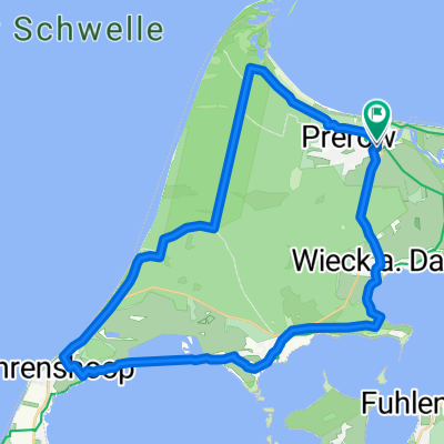
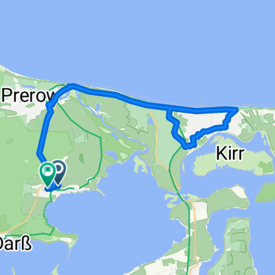
04_Prerow – Barth – Stralsund
A cycling route starting in Ostseebad Prerow, Mecklenburg-Vorpommern, Germany.
Overview
About this route
At the Cranes' Coast Character: Almost completely flat stage mostly through coastal forests over cliffs. Traffic: Only between Heiligendamm and Nienhagen must one make do with roads, from Rethwisch on a separate bike path, nearly the whole rest of the tour is car-free. Suitable guidebook: KOMPASS 6004 Baltic Sea Cycle Route 2, Bernhard Pollmann, ISBN 978-3-85026-399-3
- -:--
- Duration
- 63.2 km
- Distance
- 68 m
- Ascent
- 69 m
- Descent
- ---
- Avg. speed
- ---
- Max. altitude

Route highlights
Points of interest along the route

Point of interest after 19.8 km
Fangelturm in der Vinetastadt Barth. (Foto: Exler): Die Vinetastadt Barth ist das östliche Tor zur Ferienhalbinsel Fischland-Darß-Zingst. Wer über die Barther Hafenpromenade schlendert und über die Wasserfläche des Barther Boddens hinweg zu den Wäldern auf dem Zingst blickt, gelangt zu einer Install

Point of interest after 62.5 km
Stralsund, Hafeninsel: Die Hansestadt Stralsund liegt am Strelasund, einem schmalen Meeresarm zwischen dem Festland und der Insel Rügen. Die größte Stadt Vorpommerns ist eines der bedeutendsten städtebaulichen Kunstwerke an der Ostsee, die Altstadt mit ihren Wohnspeicherhäusern, Kirchen und dem spät
Continue with Bikemap
Use, edit, or download this cycling route
You would like to ride 04_Prerow – Barth – Stralsund or customize it for your own trip? Here is what you can do with this Bikemap route:
Free features
- Save this route as favorite or in collections
- Copy & plan your own version of this route
- Sync your route with Garmin or Wahoo
Premium features
Free trial for 3 days, or one-time payment. More about Bikemap Premium.
- Navigate this route on iOS & Android
- Export a GPX / KML file of this route
- Create your custom printout (try it for free)
- Download this route for offline navigation
Discover more Premium features.
Get Bikemap PremiumFrom our community
Other popular routes starting in Ostseebad Prerow
 Hafenstraße nach Hafenstraße
- Distance
- 36.1 km
- Ascent
- 77 m
- Descent
- 77 m
- Location
- Ostseebad Prerow, Mecklenburg-Vorpommern, Germany
 Biker Highway
- Distance
- 39.4 km
- Ascent
- 19 m
- Descent
- 19 m
- Location
- Ostseebad Prerow, Mecklenburg-Vorpommern, Germany
 Prerow-Ahrenshoop
- Distance
- 29.5 km
- Ascent
- 57 m
- Descent
- 55 m
- Location
- Ostseebad Prerow, Mecklenburg-Vorpommern, Germany
 Wieck a.d. Darß zum Weststrand durch den Darßer Urwald
- Distance
- 9.5 km
- Ascent
- 27 m
- Descent
- 28 m
- Location
- Ostseebad Prerow, Mecklenburg-Vorpommern, Germany
 04_Prerow – Barth – Stralsund
- Distance
- 63.2 km
- Ascent
- 68 m
- Descent
- 69 m
- Location
- Ostseebad Prerow, Mecklenburg-Vorpommern, Germany
 Von Prerow nach Born
- Distance
- 15.9 km
- Ascent
- 928 m
- Descent
- 940 m
- Location
- Ostseebad Prerow, Mecklenburg-Vorpommern, Germany
 Wieck a.d. Darß nach Weststrand, dann Seebrücke Prerow, dann zurück nach Wieck
- Distance
- 26.3 km
- Ascent
- 52 m
- Descent
- 54 m
- Location
- Ostseebad Prerow, Mecklenburg-Vorpommern, Germany
 Wieck a.d. Darß nach Prerow und Zingst
- Distance
- 28.9 km
- Ascent
- 58 m
- Descent
- 57 m
- Location
- Ostseebad Prerow, Mecklenburg-Vorpommern, Germany
Open it in the app