

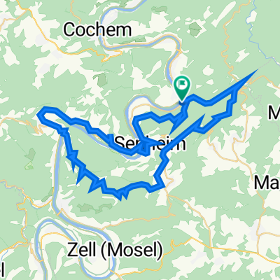
Ellenz-Koblenz
A cycling route starting in Beilstein, Rhineland-Palatinate, Germany.
Overview
About this route
Last stretch (10 km) on road without bike lane
- -:--
- Duration
- 65.6 km
- Distance
- 186 m
- Ascent
- 206 m
- Descent
- ---
- Avg. speed
- ---
- Max. altitude
Route quality
Waytypes & surfaces along the route
Waytypes
Path
17.7 km
(27 %)
Quiet road
3.9 km
(6 %)
Surfaces
Paved
54.4 km
(83 %)
Asphalt
53.8 km
(82 %)
Paved (undefined)
0.7 km
(1 %)
Undefined
11.1 km
(17 %)
Continue with Bikemap
Use, edit, or download this cycling route
You would like to ride Ellenz-Koblenz or customize it for your own trip? Here is what you can do with this Bikemap route:
Free features
- Save this route as favorite or in collections
- Copy & plan your own version of this route
- Sync your route with Garmin or Wahoo
Premium features
Free trial for 3 days, or one-time payment. More about Bikemap Premium.
- Navigate this route on iOS & Android
- Export a GPX / KML file of this route
- Create your custom printout (try it for free)
- Download this route for offline navigation
Discover more Premium features.
Get Bikemap PremiumFrom our community
Other popular routes starting in Beilstein
 Mosel Trail
- Distance
- 13.9 km
- Ascent
- 350 m
- Descent
- 360 m
- Location
- Beilstein, Rhineland-Palatinate, Germany
 Im Mühlental 6, Beilstein nach Bachstraße 39, Beilstein
- Distance
- 53.1 km
- Ascent
- 987 m
- Descent
- 1,007 m
- Location
- Beilstein, Rhineland-Palatinate, Germany
 Beilstein Cochem Beilstein
- Distance
- 51.9 km
- Ascent
- 1,118 m
- Descent
- 1,121 m
- Location
- Beilstein, Rhineland-Palatinate, Germany
 Moselsteig Etappe 18: Beilstein – Cochem
- Distance
- 13.8 km
- Ascent
- 542 m
- Descent
- 541 m
- Location
- Beilstein, Rhineland-Palatinate, Germany
 Beilstein Tag 48,5 km
- Distance
- 48.5 km
- Ascent
- 1,140 m
- Descent
- 1,142 m
- Location
- Beilstein, Rhineland-Palatinate, Germany
 Ellenz-Koblenz
- Distance
- 65.6 km
- Ascent
- 186 m
- Descent
- 206 m
- Location
- Beilstein, Rhineland-Palatinate, Germany
 Mosel 4
- Distance
- 65.6 km
- Ascent
- 204 m
- Descent
- 163 m
- Location
- Beilstein, Rhineland-Palatinate, Germany
 Beilstein - Kesten
- Distance
- 71.3 km
- Ascent
- 678 m
- Descent
- 654 m
- Location
- Beilstein, Rhineland-Palatinate, Germany
Open it in the app