
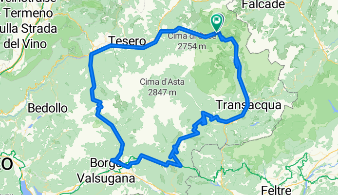
Rolle, Manghen kör (2. verz): 166 km + 4000 m
A cycling route starting in Falcade, Veneto, Italy.
Overview
About this route
Rolle, Manghen kör (2. verz): 166 km + 4000 m
- -:--
- Duration
- 166 km
- Distance
- 4,060 m
- Ascent
- 4,086 m
- Descent
- ---
- Avg. speed
- ---
- Max. altitude

Route quality
Waytypes & surfaces along the route
Waytypes
Quiet road
24.9 km
(15 %)
Road
11.6 km
(7 %)
Surfaces
Paved
112.9 km
(68 %)
Unpaved
3.3 km
(2 %)
Asphalt
91.3 km
(55 %)
Paved (undefined)
21.6 km
(13 %)
Continue with Bikemap
Use, edit, or download this cycling route
You would like to ride Rolle, Manghen kör (2. verz): 166 km + 4000 m or customize it for your own trip? Here is what you can do with this Bikemap route:
Free features
- Save this route as favorite or in collections
- Copy & plan your own version of this route
- Split it into stages to create a multi-day tour
- Sync your route with Garmin or Wahoo
Premium features
Free trial for 3 days, or one-time payment. More about Bikemap Premium.
- Navigate this route on iOS & Android
- Export a GPX / KML file of this route
- Create your custom printout (try it for free)
- Download this route for offline navigation
Discover more Premium features.
Get Bikemap PremiumFrom our community
Other popular routes starting in Falcade
 09072013 falcade - bozen
- Distance
- 159.3 km
- Ascent
- 3,052 m
- Descent
- 4,007 m
- Location
- Falcade, Veneto, Italy
 Pian dei Casoni - Baita Segantini
- Distance
- 7.3 km
- Ascent
- 506 m
- Descent
- 4 m
- Location
- Falcade, Veneto, Italy
 Falcade - Alleghe - Passo Staulanza - Longarone - Pieve di Cadore
- Distance
- 92.7 km
- Ascent
- 1,887 m
- Descent
- 2,154 m
- Location
- Falcade, Veneto, Italy
 Baita Segantini, anello
- Distance
- 11.9 km
- Ascent
- 480 m
- Descent
- 464 m
- Location
- Falcade, Veneto, Italy
 Giro Juribello Malga Venegia
- Distance
- 9.7 km
- Ascent
- 411 m
- Descent
- 409 m
- Location
- Falcade, Veneto, Italy
 Italské Alpy 2008 - Trasa 2 (Falcade - Torcegno)
- Distance
- 88.6 km
- Ascent
- 2,558 m
- Descent
- 2,995 m
- Location
- Falcade, Veneto, Italy
 20130711 falcade - falcade
- Distance
- 108.5 km
- Ascent
- 2,366 m
- Descent
- 2,366 m
- Location
- Falcade, Veneto, Italy
 Val Venegia - Baita Segantini Tour 934 - Montagna d'autore: Val Venegia - Baita Segantini
- Distance
- 19.2 km
- Ascent
- 616 m
- Descent
- 616 m
- Location
- Falcade, Veneto, Italy
Open it in the app