

Inntalradweg
A cycling route starting in Altötting, Bavaria, Germany.
Overview
About this route
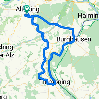
Die Strecke führt von Altötting über Teising nach Mühldorf, dann weiter durch den Golfplatz in Guttenberg nach Kraiburg am Inn. In Kraiburg wird der Inn überquert und die Fahrt geht weiter über Waldkraiburg, Ecksberg, Altmühldorf und wieder nach Mühldorf am Inn. Zurück nach Altötting führt die Stecke dann über Polling, Tüssling wieder an den Ausgangspunkt nach Altötting.
- -:--
- Duration
- 58.2 km
- Distance
- 186 m
- Ascent
- 187 m
- Descent
- ---
- Avg. speed
- ---
- Max. altitude
Route quality
Waytypes & surfaces along the route
Waytypes
Quiet road
26.2 km
(45 %)
Road
8.7 km
(15 %)
Surfaces
Paved
55.9 km
(96 %)
Unpaved
0.6 km
(1 %)
Asphalt
55.9 km
(96 %)
Gravel
0.6 km
(1 %)
Undefined
1.7 km
(3 %)
Continue with Bikemap
Use, edit, or download this cycling route
You would like to ride Inntalradweg or customize it for your own trip? Here is what you can do with this Bikemap route:
Free features
- Save this route as favorite or in collections
- Copy & plan your own version of this route
- Sync your route with Garmin or Wahoo
Premium features
Free trial for 3 days, or one-time payment. More about Bikemap Premium.
- Navigate this route on iOS & Android
- Export a GPX / KML file of this route
- Create your custom printout (try it for free)
- Download this route for offline navigation
Discover more Premium features.
Get Bikemap PremiumFrom our community
Other popular routes starting in Altötting
 Radl Via Maria 1. Etappe
- Distance
- 97.8 km
- Ascent
- 463 m
- Descent
- 391 m
- Location
- Altötting, Bavaria, Germany
 Altötting-Winhöring-Reischach-Perach-Altötting
- Distance
- 36.9 km
- Ascent
- 268 m
- Descent
- 269 m
- Location
- Altötting, Bavaria, Germany
 Altötting - Waldkraiburg - Altötting
- Distance
- 60.9 km
- Ascent
- 201 m
- Descent
- 202 m
- Location
- Altötting, Bavaria, Germany
 AÖ - Winhöring - Mühldorf - Unterneukirchen - AÖ
- Distance
- 52.1 km
- Ascent
- 215 m
- Descent
- 214 m
- Location
- Altötting, Bavaria, Germany
 Route in Altötting
- Distance
- 71.4 km
- Ascent
- 560 m
- Descent
- 557 m
- Location
- Altötting, Bavaria, Germany
 Altötting-Mühldorf-Polling_tüssling-Altötting
- Distance
- 34.6 km
- Ascent
- 133 m
- Descent
- 139 m
- Location
- Altötting, Bavaria, Germany
 Ausweichroute des 1.Altöttinger Radltags (Wetterbedingt)
- Distance
- 31.1 km
- Ascent
- 149 m
- Descent
- 150 m
- Location
- Altötting, Bavaria, Germany
 Altöttinger Radltag 2019 (Kinderrunde am Inn)
- Distance
- 11.1 km
- Ascent
- 41 m
- Descent
- 39 m
- Location
- Altötting, Bavaria, Germany
Open it in the app