

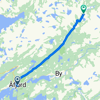
Ratvika- Trondheim
A cycling route starting in Å, Sør-Trøndelag Fylke, Norway.
Overview
About this route
Start på turen fra Ørnes
- -:--
- Duration
- 76.1 km
- Distance
- 863 m
- Ascent
- 844 m
- Descent
- ---
- Avg. speed
- ---
- Max. altitude

Route quality
Waytypes & surfaces along the route
Waytypes
Access road
9.1 km
(12 %)
Quiet road
3 km
(4 %)
Surfaces
Paved
58.6 km
(77 %)
Unpaved
3.8 km
(5 %)
Asphalt
58.6 km
(77 %)
Gravel
3.8 km
(5 %)
Undefined
13.7 km
(18 %)
Continue with Bikemap
Use, edit, or download this cycling route
You would like to ride Ratvika- Trondheim or customize it for your own trip? Here is what you can do with this Bikemap route:
Free features
- Save this route as favorite or in collections
- Copy & plan your own version of this route
- Sync your route with Garmin or Wahoo
Premium features
Free trial for 3 days, or one-time payment. More about Bikemap Premium.
- Navigate this route on iOS & Android
- Export a GPX / KML file of this route
- Create your custom printout (try it for free)
- Download this route for offline navigation
Discover more Premium features.
Get Bikemap PremiumFrom our community
Other popular routes starting in Å
 Botengård - Stokkøya B
- Distance
- 47 km
- Ascent
- 428 m
- Descent
- 422 m
- Location
- Å, Sør-Trøndelag Fylke, Norway
 Åfjord - Momyr
- Distance
- 24.3 km
- Ascent
- 618 m
- Descent
- 346 m
- Location
- Å, Sør-Trøndelag Fylke, Norway
 Stokkøya - Vingsand A
- Distance
- 15.5 km
- Ascent
- 220 m
- Descent
- 220 m
- Location
- Å, Sør-Trøndelag Fylke, Norway
 Afjord - Namsos
- Distance
- 138 km
- Ascent
- 0 m
- Descent
- 0 m
- Location
- Å, Sør-Trøndelag Fylke, Norway
 Åfjord Radfahren
- Distance
- 62.5 km
- Ascent
- 823 m
- Descent
- 844 m
- Location
- Å, Sør-Trøndelag Fylke, Norway
 kringsvatnet namsos
- Distance
- 159.4 km
- Ascent
- 1,072 m
- Descent
- 1,167 m
- Location
- Å, Sør-Trøndelag Fylke, Norway
 74. Åfjord to Trondheim
- Distance
- 98.1 km
- Ascent
- 1,805 m
- Descent
- 1,798 m
- Location
- Å, Sør-Trøndelag Fylke, Norway
 Åfjord - Lysøysundet
- Distance
- 53.1 km
- Ascent
- 1,185 m
- Descent
- 1,259 m
- Location
- Å, Sør-Trøndelag Fylke, Norway
Open it in the app