

Rauschbergrunde
A cycling route starting in Ruhpolding, Bavaria, Germany.
Overview
About this route
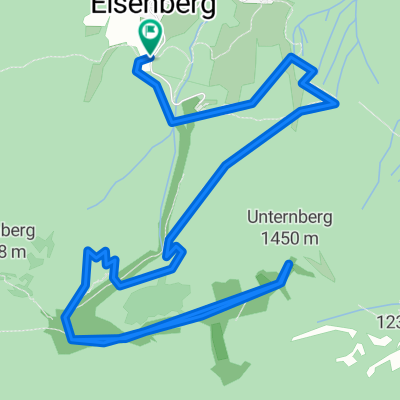
Easy tour around the Rauschberg.
Start at the parking lot of the Speedway Stadium Ruhpolding - On the main road, right over the bridge towards Zell. Then towards Inzell - diversion Gasthof Schmelz - past the hiker parking lot at "Kienbergl" to Cafe Zwing. Descend the Queralpenstraße, passing the glacier garden. Just before Weißbach, turn right at the hiker parking lot towards Haaralm / Bichler Alm / Reiteralm / Klause. There are plenty of forks. Mostly keep to the right towards Klause. There are many paths that ultimately (almost :)!) all somehow lead to Ruhpolding (with a little local knowledge).
(cloned from route 2629320)
- -:--
- Duration
- 26.4 km
- Distance
- 588 m
- Ascent
- 588 m
- Descent
- ---
- Avg. speed
- ---
- Max. altitude
Continue with Bikemap
Use, edit, or download this cycling route
You would like to ride Rauschbergrunde or customize it for your own trip? Here is what you can do with this Bikemap route:
Free features
- Save this route as favorite or in collections
- Copy & plan your own version of this route
- Sync your route with Garmin or Wahoo
Premium features
Free trial for 3 days, or one-time payment. More about Bikemap Premium.
- Navigate this route on iOS & Android
- Export a GPX / KML file of this route
- Create your custom printout (try it for free)
- Download this route for offline navigation
Discover more Premium features.
Get Bikemap PremiumFrom our community
Other popular routes starting in Ruhpolding
 D_Bayern-Fuchsau-Gstatt-Steinbachalm-HochfellnMittelstation-Scheichenbergalm-MariaEckWeg-Dießelbachweg-ChiemgauCoaster-Ruhpolding_RR-26km-650hm
- Distance
- 26.1 km
- Ascent
- 613 m
- Descent
- 613 m
- Location
- Ruhpolding, Bavaria, Germany
 Rund um den Hochfelln
- Distance
- 40.3 km
- Ascent
- 971 m
- Descent
- 967 m
- Location
- Ruhpolding, Bavaria, Germany
 HIPP-Trophy
- Distance
- 1.3 km
- Ascent
- 30 m
- Descent
- 30 m
- Location
- Ruhpolding, Bavaria, Germany
 Pedale - Bergen
- Distance
- 32.3 km
- Ascent
- 280 m
- Descent
- 286 m
- Location
- Ruhpolding, Bavaria, Germany
 Jochbergalm
- Distance
- 19.7 km
- Ascent
- 660 m
- Descent
- 656 m
- Location
- Ruhpolding, Bavaria, Germany
 Unternbergbahn, Ruhpolding nach Unternbergbahn, Ruhpolding
- Distance
- 10.6 km
- Ascent
- 583 m
- Descent
- 583 m
- Location
- Ruhpolding, Bavaria, Germany
 Röthelmoss Runde
- Distance
- 30.6 km
- Ascent
- 340 m
- Descent
- 340 m
- Location
- Ruhpolding, Bavaria, Germany
 Ruhpolding-Dandl Alm-Jochberg Alm-Ruhpolding CLONED FROM ROUTE 1704365
- Distance
- 37.9 km
- Ascent
- 684 m
- Descent
- 686 m
- Location
- Ruhpolding, Bavaria, Germany
Open it in the app