Ciclo Ruta SANTA ANA
A cycling route starting in Puyo, Pastaza Province, Ecuador.
Overview
About this route
FEATURES Distance: 26.39 Km. Continuous cycling time: 3hrs. Time at stops: 5hrs. Difficulty: Medium Surface: 70 % Asphalt. 30% Gravel Users: Children, Youth, Adults.
SERVICES Food: Yes Accommodation: Yes Tour Guide: Yes ACTIVITIES Bird Watching Trekking Cave Visit Landscape Photography Portrait Photography Flora and Fauna Photography Camping Traditional Dance River Swimming- -:--
- Duration
- 26.4 km
- Distance
- 35 m
- Ascent
- 264 m
- Descent
- ---
- Avg. speed
- ---
- Max. altitude
Route quality
Waytypes & surfaces along the route
Waytypes
Road
17.4 km
(66 %)
Quiet road
7.4 km
(28 %)
Cycleway
1.6 km
(6 %)
Surfaces
Paved
2.4 km
(9 %)
Unpaved
5.3 km
(20 %)
Unpaved (undefined)
5.3 km
(20 %)
Asphalt
2.1 km
(8 %)
Route highlights
Points of interest along the route
Point of interest after 0 km
INICIO CICLO RUTA SANTA ANA Parque Central de Shell
Point of interest after 0.1 km
MERCADO MUNICIPAL DE SHELL
Point of interest after 0.5 km
PUENTE COLGANTE Fotografía Observación de Aves
Point of interest after 0.7 km
AEROPUERTO
Point of interest after 1.6 km
Entrada a la parroquia Madre Tierra. Sólo acceso con vehículo.
Point of interest after 2.1 km
Desvío a Te Zulay

Point of interest after 3.4 km
ATRACTIVO TURÍSTICO La Casa Del Árbol Pastaza
Point of interest after 4.9 km
Asociación Acuña.

Point of interest after 8.1 km
MUSEO ARTESANAL "AGUA VIVA" Artesanías indígenas de Pastaza. Elaboración de mucawas, demostración de artesanías
Point of interest after 8.1 km
Parque Central de la parroquia Madre Tierra Canchas de fútbol
Point of interest after 8.1 km
Tienda Alimentos Hidratación SS.HH
Point of interest after 9.6 km
Comunidad "San José"
Point of interest after 11.6 km
Comunidad "Paz Yaku"

Point of interest after 13 km
Comunidad "Playas del Pastaza" Danza Tradicional
Point of interest after 14.7 km
Comunidad "Yana Amaru"
Point of interest after 18.6 km
Comunidad "Amazonas"
Point of interest after 20.2 km
Comunidad "La Libertad"
Point of interest after 23.8 km
Comunidad "Paushi YAku" Jardín Botánico "Yaku Runa"

Photo after 26.3 km
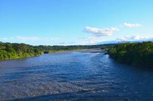
Mirador del río Pastaza Tarabita del río Pastaza

Point of interest after 26.4 km
Comunidad Santa Ana Alimentación
Continue with Bikemap
Use, edit, or download this cycling route
You would like to ride Ciclo Ruta SANTA ANA or customize it for your own trip? Here is what you can do with this Bikemap route:
Free features
- Save this route as favorite or in collections
- Copy & plan your own version of this route
- Sync your route with Garmin or Wahoo
Premium features
Free trial for 3 days, or one-time payment. More about Bikemap Premium.
- Navigate this route on iOS & Android
- Export a GPX / KML file of this route
- Create your custom printout (try it for free)
- Download this route for offline navigation
Discover more Premium features.
Get Bikemap PremiumFrom our community
Other popular routes starting in Puyo
 Mera regalo a la Tierra
- Distance
- 15.4 km
- Ascent
- 141 m
- Descent
- 184 m
- Location
- Puyo, Pastaza Province, Ecuador
 RUTA PUYO-TENA EMBICIADOS DEL ZURICH.
- Distance
- 76.7 km
- Ascent
- 531 m
- Descent
- 943 m
- Location
- Puyo, Pastaza Province, Ecuador
 Ciclo Ruta Puyo - Fátima
- Distance
- 8.2 km
- Ascent
- 120 m
- Descent
- 49 m
- Location
- Puyo, Pastaza Province, Ecuador
 Ciclo Ruta SANTA ANA
- Distance
- 26.4 km
- Ascent
- 35 m
- Descent
- 264 m
- Location
- Puyo, Pastaza Province, Ecuador
 Ciclo Paseo Nocturno
- Distance
- 12.8 km
- Ascent
- ---
- Descent
- ---
- Location
- Puyo, Pastaza Province, Ecuador
 Sacha runa - Miravia
- Distance
- 3.2 km
- Ascent
- 76 m
- Descent
- 37 m
- Location
- Puyo, Pastaza Province, Ecuador
 Ciclo Ruta El Triunfo
- Distance
- 13 km
- Ascent
- 131 m
- Descent
- 72 m
- Location
- Puyo, Pastaza Province, Ecuador
 Ciclo Ruta El Triunfo
- Distance
- 28.3 km
- Ascent
- 236 m
- Descent
- 102 m
- Location
- Puyo, Pastaza Province, Ecuador
Open it in the app


