

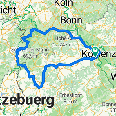
Niederfell 47 km Tour
A cycling route starting in Winningen, Rhineland-Palatinate, Germany.
Overview
About this route
Niederfell/ Winningen/ Deiteche Eckund on the Rhine return
- -:--
- Duration
- 47.1 km
- Distance
- 365 m
- Ascent
- 367 m
- Descent
- ---
- Avg. speed
- ---
- Max. altitude
Route quality
Waytypes & surfaces along the route
Waytypes
Quiet road
10.8 km
(23 %)
Track
10.8 km
(23 %)
Surfaces
Paved
35.8 km
(76 %)
Unpaved
4.2 km
(9 %)
Asphalt
26.8 km
(57 %)
Paved (undefined)
8.5 km
(18 %)
Continue with Bikemap
Use, edit, or download this cycling route
You would like to ride Niederfell 47 km Tour or customize it for your own trip? Here is what you can do with this Bikemap route:
Free features
- Save this route as favorite or in collections
- Copy & plan your own version of this route
- Sync your route with Garmin or Wahoo
Premium features
Free trial for 3 days, or one-time payment. More about Bikemap Premium.
- Navigate this route on iOS & Android
- Export a GPX / KML file of this route
- Create your custom printout (try it for free)
- Download this route for offline navigation
Discover more Premium features.
Get Bikemap PremiumFrom our community
Other popular routes starting in Winningen
 Niederfell 47 km Tour
- Distance
- 47.1 km
- Ascent
- 365 m
- Descent
- 367 m
- Location
- Winningen, Rhineland-Palatinate, Germany
 Moselweinstraße, Koblenz nach Am Plan 1, Koblenz
- Distance
- 10.7 km
- Ascent
- 73 m
- Descent
- 28 m
- Location
- Winningen, Rhineland-Palatinate, Germany
 Winningen nach Löf
- Distance
- 14.8 km
- Ascent
- 204 m
- Descent
- 208 m
- Location
- Winningen, Rhineland-Palatinate, Germany
 Hexenpfad
- Distance
- 8.8 km
- Ascent
- 352 m
- Descent
- 352 m
- Location
- Winningen, Rhineland-Palatinate, Germany
 B416, Winningen to Koblenzer Straße 184–186, Koblenz
- Distance
- 18.1 km
- Ascent
- 172 m
- Descent
- 170 m
- Location
- Winningen, Rhineland-Palatinate, Germany
 Eifel
Eifel- Distance
- 394.8 km
- Ascent
- 1,468 m
- Descent
- 1,472 m
- Location
- Winningen, Rhineland-Palatinate, Germany
 1993 - Mosel rauf - Nahe runter - 2. Tag - Winningen - Valwig
- Distance
- 44.2 km
- Ascent
- 355 m
- Descent
- 341 m
- Location
- Winningen, Rhineland-Palatinate, Germany
 Moezel
- Distance
- 122.7 km
- Ascent
- 574 m
- Descent
- 519 m
- Location
- Winningen, Rhineland-Palatinate, Germany
Open it in the app