

Tour de France 2016 - Stage 02
A cycling route starting in Saint-Lô, Normandy, France.
Overview
About this route
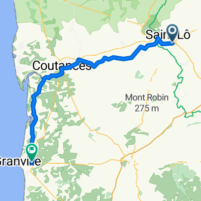
Tour de France 2016 - Stage 02
Saint-Lô > Cherbourg-Octeville- -:--
- Duration
- 187 km
- Distance
- 934 m
- Ascent
- 857 m
- Descent
- ---
- Avg. speed
- ---
- Max. altitude

Route quality
Waytypes & surfaces along the route
Waytypes
Road
50.5 km
(27 %)
Quiet road
26.2 km
(14 %)
Surfaces
Paved
129 km
(69 %)
Asphalt
127.1 km
(68 %)
Paved (undefined)
1.9 km
(1 %)
Undefined
58 km
(31 %)
Continue with Bikemap
Use, edit, or download this cycling route
You would like to ride Tour de France 2016 - Stage 02 or customize it for your own trip? Here is what you can do with this Bikemap route:
Free features
- Save this route as favorite or in collections
- Copy & plan your own version of this route
- Split it into stages to create a multi-day tour
- Sync your route with Garmin or Wahoo
Premium features
Free trial for 3 days, or one-time payment. More about Bikemap Premium.
- Navigate this route on iOS & Android
- Export a GPX / KML file of this route
- Create your custom printout (try it for free)
- Download this route for offline navigation
Discover more Premium features.
Get Bikemap PremiumFrom our community
Other popular routes starting in Saint-Lô
 Saint-Lô (Ibis Budget) - (Centre Ville) Saint-Lô
- Distance
- 3.7 km
- Ascent
- 8 m
- Descent
- 89 m
- Location
- Saint-Lô, Normandy, France
 F 10 bis Saint-Lô - Commes
- Distance
- 88.3 km
- Ascent
- 626 m
- Descent
- 631 m
- Location
- Saint-Lô, Normandy, France
 vendrzedi duDe Rue Torteron 17, Saint-Lô à La Garchiniére 4, Saint-Brice-de-Landelles
- Distance
- 145.4 km
- Ascent
- 1,928 m
- Descent
- 1,772 m
- Location
- Saint-Lô, Normandy, France
 Saint-Lo - Avranches
- Distance
- 62.7 km
- Ascent
- 566 m
- Descent
- 505 m
- Location
- Saint-Lô, Normandy, France
 La Chevalerie nach Route de Villedieu
- Distance
- 67.8 km
- Ascent
- 575 m
- Descent
- 612 m
- Location
- Saint-Lô, Normandy, France
 1. prologo crono SAINT LO
- Distance
- 3.7 km
- Ascent
- 81 m
- Descent
- 76 m
- Location
- Saint-Lô, Normandy, France
 Tour de France 2016 - Stage 2
- Distance
- 190.2 km
- Ascent
- 855 m
- Descent
- 721 m
- Location
- Saint-Lô, Normandy, France
 Tour de France 2016 - Stage 02
- Distance
- 187 km
- Ascent
- 934 m
- Descent
- 857 m
- Location
- Saint-Lô, Normandy, France
Open it in the app