
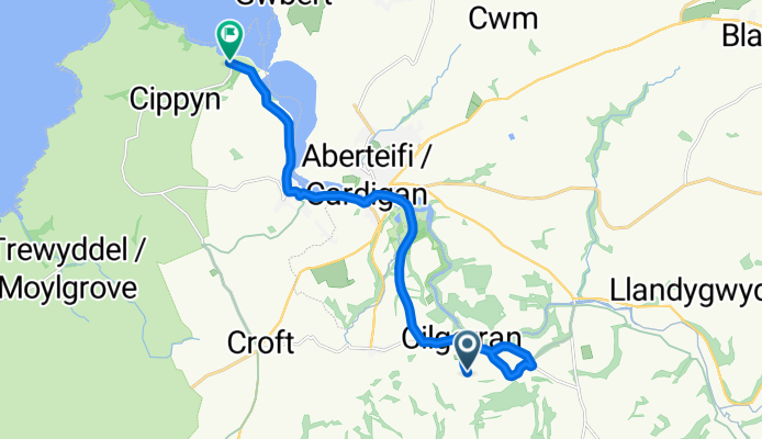
Poppit
A cycling route starting in Cardigan, Wales, United Kingdom.
Overview
About this route
Poppit road
- -:--
- Duration
- 13.4 km
- Distance
- 114 m
- Ascent
- 170 m
- Descent
- ---
- Avg. speed
- ---
- Max. altitude
Route quality
Waytypes & surfaces along the route
Waytypes
Road
2.9 km
(22 %)
Access road
2.1 km
(16 %)
Surfaces
Paved
7.5 km
(56 %)
Asphalt
7.5 km
(56 %)
Undefined
5.9 km
(44 %)
Route highlights
Points of interest along the route
Point of interest after 2.4 km
hill
Point of interest after 2.5 km
hill
Point of interest after 5.7 km
sprint point zone
Point of interest after 11.2 km
hill zone
Point of interest after 11.7 km
hill zone
Point of interest after 12.9 km
start sprint
Point of interest after 13.3 km
sprint point zone end
Continue with Bikemap
Use, edit, or download this cycling route
You would like to ride Poppit or customize it for your own trip? Here is what you can do with this Bikemap route:
Free features
- Save this route as favorite or in collections
- Copy & plan your own version of this route
- Sync your route with Garmin or Wahoo
Premium features
Free trial for 3 days, or one-time payment. More about Bikemap Premium.
- Navigate this route on iOS & Android
- Export a GPX / KML file of this route
- Create your custom printout (try it for free)
- Download this route for offline navigation
Discover more Premium features.
Get Bikemap PremiumFrom our community
Other popular routes starting in Cardigan
 Wales Coast Leg 5 Cardigan - Pembroke
- Distance
- 116.7 km
- Ascent
- 772 m
- Descent
- 790 m
- Location
- Cardigan, Wales, United Kingdom
 Wales Coast 5
- Distance
- 87.3 km
- Ascent
- 764 m
- Descent
- 764 m
- Location
- Cardigan, Wales, United Kingdom
 44k St Dogmaels
- Distance
- 44.7 km
- Ascent
- 687 m
- Descent
- 667 m
- Location
- Cardigan, Wales, United Kingdom
 Stage 5: Trefasser to Pant yr Athro
- Distance
- 130.8 km
- Ascent
- 910 m
- Descent
- 1,013 m
- Location
- Cardigan, Wales, United Kingdom
 Extensive Montag Course In Cardigan
- Distance
- 5.5 km
- Ascent
- 42 m
- Descent
- 60 m
- Location
- Cardigan, Wales, United Kingdom
 Poppit
- Distance
- 13.4 km
- Ascent
- 114 m
- Descent
- 170 m
- Location
- Cardigan, Wales, United Kingdom
 Boncath
- Distance
- 17.5 km
- Ascent
- 252 m
- Descent
- 252 m
- Location
- Cardigan, Wales, United Kingdom
 cardigan to holyhead
- Distance
- 257.7 km
- Ascent
- 1,465 m
- Descent
- 1,470 m
- Location
- Cardigan, Wales, United Kingdom
Open it in the app