

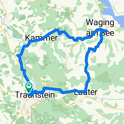
D 227: Traunstein - Kufstein
A cycling route starting in Traunstein, Bavaria, Germany.
Overview
About this route
- -:--
- Duration
- 72.1 km
- Distance
- 450 m
- Ascent
- 552 m
- Descent
- ---
- Avg. speed
- ---
- Max. altitude
Route quality
Waytypes & surfaces along the route
Waytypes
Quiet road
19.5 km
(27 %)
Track
16.6 km
(23 %)
Surfaces
Paved
52.6 km
(73 %)
Unpaved
15.9 km
(22 %)
Asphalt
52.6 km
(73 %)
Gravel
14.4 km
(20 %)
Route highlights
Points of interest along the route
Accommodation after 0 km
Rosenheimer Hof
Drinking water after 2 km
Traun
Drinking water after 10 km
Weiße Traun
Drinking water after 13 km
Weiße Traun
Drinking water after 14.9 km
Weiße Traun
Photo after 18.6 km
Chiemgau Arena
Drinking water after 21.2 km
Förchensee
Drinking water after 24.3 km
Lödensee
Drinking water after 25.1 km
Mittersee
Drinking water after 27.2 km
Weitsee
Drinking water after 35.7 km
Schwarzlofer
Drinking water after 41.4 km
Lofer
Drinking water after 46 km
Großache
Drinking water after 54 km
Walchsee
Photo after 61.6 km
Panoramastrecke (vom Feinsten)
Photo after 62.9 km
Kirche Hl. St. Nikolaus
Drinking water after 66.2 km
Inn
Drinking water after 71.5 km
Inn
Photo after 71.5 km
Batzenhäusl
Photo after 71.5 km
Altstadt
Photo after 71.6 km
Unterer Stadtplatz
Photo after 71.8 km
Oberer Stadtplatz
Photo after 71.8 km
Stadtpfarrkirche St. Vitus
Photo after 71.9 km
Festung Kufstein
Accommodation after 72.1 km
Andreas Hofer
Photo after 72.1 km
Bezirksgericht
Continue with Bikemap
Use, edit, or download this cycling route
You would like to ride D 227: Traunstein - Kufstein or customize it for your own trip? Here is what you can do with this Bikemap route:
Free features
- Save this route as favorite or in collections
- Copy & plan your own version of this route
- Sync your route with Garmin or Wahoo
Premium features
Free trial for 3 days, or one-time payment. More about Bikemap Premium.
- Navigate this route on iOS & Android
- Export a GPX / KML file of this route
- Create your custom printout (try it for free)
- Download this route for offline navigation
Discover more Premium features.
Get Bikemap PremiumFrom our community
Other popular routes starting in Traunstein
 Brauereitour 2 - Chiemsee und Alz, Hopfen und Malz
- Distance
- 62.7 km
- Ascent
- 608 m
- Descent
- 609 m
- Location
- Traunstein, Bavaria, Germany
 Traunstein um Waging am See
- Distance
- 46.6 km
- Ascent
- 418 m
- Descent
- 419 m
- Location
- Traunstein, Bavaria, Germany
 Gut Edermann über Siegsdorf
- Distance
- 43.4 km
- Ascent
- 348 m
- Descent
- 348 m
- Location
- Traunstein, Bavaria, Germany
 Traunstein zum Landhaus Tanner
- Distance
- 34.6 km
- Ascent
- 339 m
- Descent
- 339 m
- Location
- Traunstein, Bavaria, Germany
 Traunstein-Chieming-Traunstein
- Distance
- 26.3 km
- Ascent
- 210 m
- Descent
- 209 m
- Location
- Traunstein, Bavaria, Germany
 Rund um Traunstein
- Distance
- 47.5 km
- Ascent
- 590 m
- Descent
- 589 m
- Location
- Traunstein, Bavaria, Germany
 Hartseestüberl
- Distance
- 26.3 km
- Ascent
- 91 m
- Descent
- 156 m
- Location
- Traunstein, Bavaria, Germany
 Alte Panzerstraße, Traunstein nach Siegerthöhe 2, Trostberg
- Distance
- 22.4 km
- Ascent
- 94 m
- Descent
- 142 m
- Location
- Traunstein, Bavaria, Germany
Open it in the app