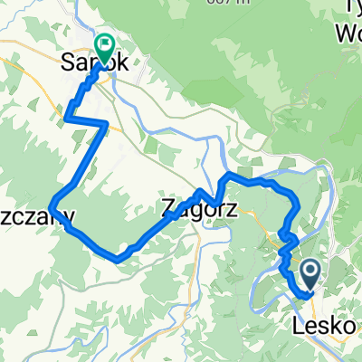
5A "wzg贸rze gruszka"
A cycling route starting in Lesko, Subcarpathian Voivodeship, Poland.
Overview
About this route
Lesko-Tarnawa G贸rna - Kalnica - Roztoki G贸rne - Nowosi贸艂ki - Weremie艅 - Lesko
- -:--
- Duration
- 44.3 km
- Distance
- 429 m
- Ascent
- 451 m
- Descent
- ---
- Avg. speed
- ---
- Max. altitude
Route quality
Waytypes & surfaces along the route
Waytypes
Road
25.3 km
(57 %)
Quiet road
1.8 km
(4 %)
Surfaces
Paved
43 km
(97 %)
Unpaved
0.4 km
(1 %)
Asphalt
43 km
(97 %)
Ground
0.4 km
(1 %)
Undefined
0.9 km
(2 %)
Continue with Bikemap
Use, edit, or download this cycling route
You would like to ride 5A "wzg贸rze gruszka" or customize it for your own trip? Here is what you can do with this Bikemap route:
Free features
- Save this route as favorite or in collections
- Copy & plan your own version of this route
- Sync your route with Garmin or Wahoo
Premium features
Free trial for 3 days, or one-time payment. More about Bikemap Premium.
- Navigate this route on iOS & Android
- Export a GPX / KML file of this route
- Create your custom printout (try it for free)
- Download this route for offline navigation
Discover more Premium features.
Get Bikemap PremiumFrom our community
Other popular routes starting in Lesko
- Lesko-B贸brka-Myczkowce-Lesko
- Distance
- 27.3 km
- Ascent
- 399 m
- Descent
- 408 m
- Location
- Lesko, Subcarpathian Voivodeship, Poland
- Wielka P臋tla Bieszczadzka
- Distance
- 151.8 km
- Ascent
- 2,107 m
- Descent
- 2,105 m
- Location
- Lesko, Subcarpathian Voivodeship, Poland
- bieszczady 2015 kmikazze
- Distance
- 149.4 km
- Ascent
- 1,360 m
- Descent
- 1,362 m
- Location
- Lesko, Subcarpathian Voivodeship, Poland
- Lesko - Rzeped藕 - Koma艅cza - Cisna - Baligr贸d - Lesko
- Distance
- 100.3 km
- Ascent
- 953 m
- Descent
- 976 m
- Location
- Lesko, Subcarpathian Voivodeship, Poland
- 3/3 Dooko艂a Soliny
- Distance
- 99.2 km
- Ascent
- 654 m
- Descent
- 757 m
- Location
- Lesko, Subcarpathian Voivodeship, Poland
- Lesko-Tarnawa G贸rna-Zag贸rz-Lesko
- Distance
- 21 km
- Ascent
- 345 m
- Descent
- 342 m
- Location
- Lesko, Subcarpathian Voivodeship, Poland
- wersja 2 mapa nie puszcza przez zapore
- Distance
- 138.1 km
- Ascent
- 1,252 m
- Descent
- 1,259 m
- Location
- Lesko, Subcarpathian Voivodeship, Poland
- Ma艂a P臋tla Bieszczadzka
- Distance
- 95.6 km
- Ascent
- 911 m
- Descent
- 911 m
- Location
- Lesko, Subcarpathian Voivodeship, Poland
Open it in the app