

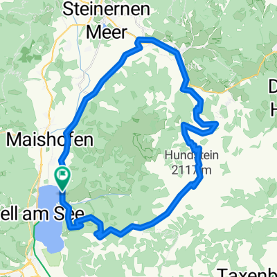
Ramseidner Runde
A cycling route starting in Zell am See, Salzburg, Austria.
Overview
About this route
Wunderschöne Runde mit einer kurzen Tragepassage und herrlichem Singletrail.
Von Zell am See auf dem Radweg nach Maria Alm, dort nach links weg zum Krallerwinkel, weiter richtung Grießbachwinkel, Gasthof Kronreit, weiter am Forstweg bis zum Ende des Weges. Hier links rauf eine Tragepassage. Dann folgt ein herrlicher Singletrail bis nach Saalfelden.
Einmal muß man eine Forststraße queren. Hier aufpassen, dass man den Einstieg in den Singletrail nicht verpasst.
- -:--
- Duration
- 55.5 km
- Distance
- 691 m
- Ascent
- 693 m
- Descent
- ---
- Avg. speed
- ---
- Max. altitude

Continue with Bikemap
Use, edit, or download this cycling route
You would like to ride Ramseidner Runde or customize it for your own trip? Here is what you can do with this Bikemap route:
Free features
- Save this route as favorite or in collections
- Copy & plan your own version of this route
- Sync your route with Garmin or Wahoo
Premium features
Free trial for 3 days, or one-time payment. More about Bikemap Premium.
- Navigate this route on iOS & Android
- Export a GPX / KML file of this route
- Create your custom printout (try it for free)
- Download this route for offline navigation
Discover more Premium features.
Get Bikemap PremiumFrom our community
Other popular routes starting in Zell am See
 Ramseidner Runde
- Distance
- 55.5 km
- Ascent
- 691 m
- Descent
- 693 m
- Location
- Zell am See, Salzburg, Austria
 ZA3 Schmittenhöhe 31.7.2017
- Distance
- 39.3 km
- Ascent
- 1,392 m
- Descent
- 1,391 m
- Location
- Zell am See, Salzburg, Austria
 Zell am See - Bad Gastein
- Distance
- 52.2 km
- Ascent
- 1,101 m
- Descent
- 802 m
- Location
- Zell am See, Salzburg, Austria
 Hundstein
- Distance
- 42 km
- Ascent
- 1,413 m
- Descent
- 1,413 m
- Location
- Zell am See, Salzburg, Austria
 IRONMAN 70.3 Zell am See / Kaprun
- Distance
- 89.7 km
- Ascent
- 802 m
- Descent
- 804 m
- Location
- Zell am See, Salzburg, Austria
 Gravel bike route: Seeblickrunde
- Distance
- 37.6 km
- Ascent
- 887 m
- Descent
- 886 m
- Location
- Zell am See, Salzburg, Austria
 2014 IRONMAN 70.3 Zell am See / Kaprun
- Distance
- 90.4 km
- Ascent
- 753 m
- Descent
- 753 m
- Location
- Zell am See, Salzburg, Austria
 Zell Am See - Around the lake
- Distance
- 18.6 km
- Ascent
- 124 m
- Descent
- 125 m
- Location
- Zell am See, Salzburg, Austria
Open it in the app