

Mühltal
A cycling route starting in Gera, Thuringia, Germany.
Overview
About this route
Circular route from Gera through the Mühltal valley back to Gera
- -:--
- Duration
- 44.9 km
- Distance
- 298 m
- Ascent
- 299 m
- Descent
- ---
- Avg. speed
- ---
- Max. altitude
Route quality
Waytypes & surfaces along the route
Waytypes
Quiet road
14.4 km
(32 %)
Path
13 km
(29 %)
Surfaces
Paved
36.8 km
(82 %)
Unpaved
4.9 km
(11 %)
Asphalt
33.2 km
(74 %)
Paved (undefined)
3.6 km
(8 %)
Continue with Bikemap
Use, edit, or download this cycling route
You would like to ride Mühltal or customize it for your own trip? Here is what you can do with this Bikemap route:
Free features
- Save this route as favorite or in collections
- Copy & plan your own version of this route
- Sync your route with Garmin or Wahoo
Premium features
Free trial for 3 days, or one-time payment. More about Bikemap Premium.
- Navigate this route on iOS & Android
- Export a GPX / KML file of this route
- Create your custom printout (try it for free)
- Download this route for offline navigation
Discover more Premium features.
Get Bikemap PremiumFrom our community
Other popular routes starting in Gera
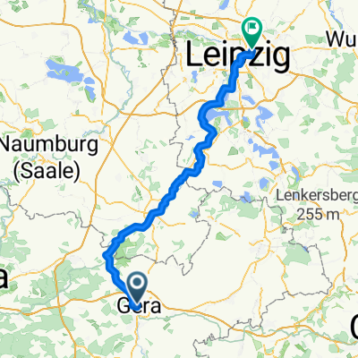 Gera nach Leipzig
- Distance
- 86.4 km
- Ascent
- 334 m
- Descent
- 405 m
- Location
- Gera, Thuringia, Germany
 Relaxed Freitag Route In Gera
- Distance
- 16.1 km
- Ascent
- 204 m
- Descent
- 201 m
- Location
- Gera, Thuringia, Germany
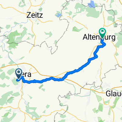 Gera - Altenburg
- Distance
- 43 km
- Ascent
- 306 m
- Descent
- 351 m
- Location
- Gera, Thuringia, Germany
 Mühltal
- Distance
- 44.9 km
- Ascent
- 298 m
- Descent
- 299 m
- Location
- Gera, Thuringia, Germany
 RBT Gera-Jena
- Distance
- 45.8 km
- Ascent
- 345 m
- Descent
- 414 m
- Location
- Gera, Thuringia, Germany
 Von Gera bis Crossen an der Elster
- Distance
- 15 km
- Ascent
- 61 m
- Descent
- 108 m
- Location
- Gera, Thuringia, Germany
 tägliche Trainingrunde
- Distance
- 40.2 km
- Ascent
- 330 m
- Descent
- 324 m
- Location
- Gera, Thuringia, Germany
 Crimmitschau - Kap Arkona 2013 R 01/T01/TA02/V01
- Distance
- 29 km
- Ascent
- 171 m
- Descent
- 205 m
- Location
- Gera, Thuringia, Germany
Open it in the app