

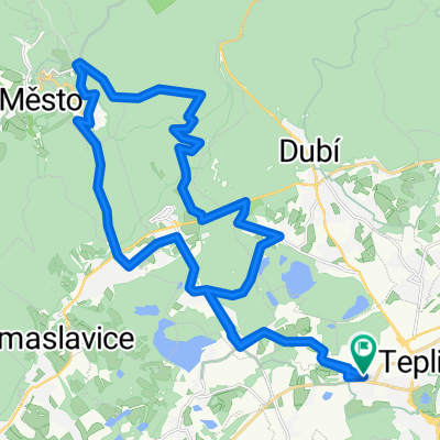
Teplice-Milada
A cycling route starting in Teplice, Ústecký kraj, Czechia.
Overview
About this route
Projížďka pro moje zada test
- -:--
- Duration
- 24.1 km
- Distance
- 177 m
- Ascent
- 186 m
- Descent
- ---
- Avg. speed
- ---
- Max. altitude
Route quality
Waytypes & surfaces along the route
Waytypes
Road
10.5 km
(44 %)
Track
9.8 km
(41 %)
Surfaces
Paved
14.2 km
(59 %)
Unpaved
5 km
(21 %)
Asphalt
12.1 km
(50 %)
Gravel
4.7 km
(19 %)
Route highlights
Points of interest along the route

Point of interest after 8.2 km

Point of interest after 12.2 km
koupačka a slunění taky langoš a dvě piva
Continue with Bikemap
Use, edit, or download this cycling route
You would like to ride Teplice-Milada or customize it for your own trip? Here is what you can do with this Bikemap route:
Free features
- Save this route as favorite or in collections
- Copy & plan your own version of this route
- Sync your route with Garmin or Wahoo
Premium features
Free trial for 3 days, or one-time payment. More about Bikemap Premium.
- Navigate this route on iOS & Android
- Export a GPX / KML file of this route
- Create your custom printout (try it for free)
- Download this route for offline navigation
Discover more Premium features.
Get Bikemap PremiumFrom our community
Other popular routes starting in Teplice
 Teplice-Cinovec-Koměří víška-Ujčínb
- Distance
- 39.9 km
- Ascent
- 766 m
- Descent
- 768 m
- Location
- Teplice, Ústecký kraj, Czechia
 Teplice-Milada
- Distance
- 24.1 km
- Ascent
- 177 m
- Descent
- 186 m
- Location
- Teplice, Ústecký kraj, Czechia
 Na Gravelu do LT
- Distance
- 52.6 km
- Ascent
- 593 m
- Descent
- 670 m
- Location
- Teplice, Ústecký kraj, Czechia
 Milča 5.8.15
- Distance
- 25.2 km
- Ascent
- 222 m
- Descent
- 222 m
- Location
- Teplice, Ústecký kraj, Czechia
 Flájská přehrada (69 km)
- Distance
- 68.7 km
- Ascent
- 970 m
- Descent
- 970 m
- Location
- Teplice, Ústecký kraj, Czechia
 Z lázeňského centra s výhledy na Krušné hory i České středohoří k řece Bílině a zpět
- Distance
- 20 km
- Ascent
- 248 m
- Descent
- 248 m
- Location
- Teplice, Ústecký kraj, Czechia
 Hakysovo kotrmelec
- Distance
- 30.2 km
- Ascent
- 656 m
- Descent
- 640 m
- Location
- Teplice, Ústecký kraj, Czechia
 kolovýlet
- Distance
- 169.5 km
- Ascent
- 639 m
- Descent
- 650 m
- Location
- Teplice, Ústecký kraj, Czechia
Open it in the app