

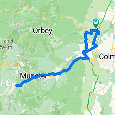
Route des Cretes Teil1 VarianteA
A cycling route starting in Sigolsheim, Grand Est, France.
Overview
About this route
Route des Cretes, Teil1
- -:--
- Duration
- 52.1 km
- Distance
- 1,342 m
- Ascent
- 348 m
- Descent
- ---
- Avg. speed
- ---
- Max. altitude
Route quality
Waytypes & surfaces along the route
Waytypes
Road
18.2 km
(35 %)
Quiet road
4.2 km
(8 %)
Surfaces
Paved
40.7 km
(78 %)
Unpaved
0.5 km
(1 %)
Asphalt
38.6 km
(74 %)
Paved (undefined)
2.1 km
(4 %)
Route highlights
Points of interest along the route
Accommodation after 52.1 km
Chalet-refuge des 3 Fours Route des Crêtes, 68140 Stosswihr, Frankreich chaletrefuge3fours.ffcam.fr 03 89 77 32 59
Continue with Bikemap
Use, edit, or download this cycling route
You would like to ride Route des Cretes Teil1 VarianteA or customize it for your own trip? Here is what you can do with this Bikemap route:
Free features
- Save this route as favorite or in collections
- Copy & plan your own version of this route
- Sync your route with Garmin or Wahoo
Premium features
Free trial for 3 days, or one-time payment. More about Bikemap Premium.
- Navigate this route on iOS & Android
- Export a GPX / KML file of this route
- Create your custom printout (try it for free)
- Download this route for offline navigation
Discover more Premium features.
Get Bikemap PremiumFrom our community
Other popular routes starting in Sigolsheim
 De Rue du Stade 8a à Rue du Stade 8a
- Distance
- 63.9 km
- Ascent
- 502 m
- Descent
- 539 m
- Location
- Sigolsheim, Grand Est, France
 Route des vins
- Distance
- 27.7 km
- Ascent
- 267 m
- Descent
- 262 m
- Location
- Sigolsheim, Grand Est, France
 Vosges#6
- Distance
- 174.2 km
- Ascent
- 2,661 m
- Descent
- 2,661 m
- Location
- Sigolsheim, Grand Est, France
 KIENTZHEIM ST HIPPOLYTE PAR LES VIGNES
- Distance
- 17.5 km
- Ascent
- 298 m
- Descent
- 278 m
- Location
- Sigolsheim, Grand Est, France
 Route des Cretes Teil1 VarianteA
- Distance
- 52.1 km
- Ascent
- 1,342 m
- Descent
- 348 m
- Location
- Sigolsheim, Grand Est, France
 C6 (Def) Sigoldsheim-Kientzheim-Bennwihr-Mittelwihr-Riquewihr-Zellenberg
- Distance
- 24.4 km
- Ascent
- 238 m
- Descent
- 240 m
- Location
- Sigolsheim, Grand Est, France
 TRB 50 - Ribeauvillé - Riquewihr - Kientzheim - Turckheim - Colmar -
- Distance
- 50.7 km
- Ascent
- 512 m
- Descent
- 511 m
- Location
- Sigolsheim, Grand Est, France
 Da Rue du Vogelgarten a Rue du Maréchal de Lattre
- Distance
- 27.4 km
- Ascent
- 266 m
- Descent
- 252 m
- Location
- Sigolsheim, Grand Est, France
Open it in the app