

ALLEYCAT - El Bananero - FESTIVAL DE ARTE EN VIVO AL AIRE LIBRE
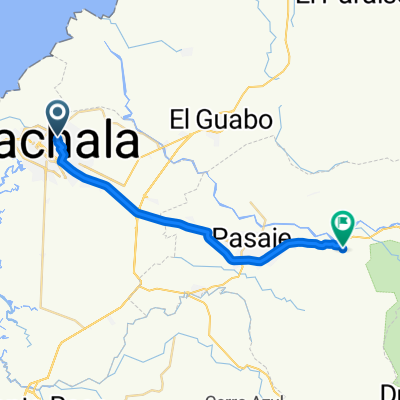
A cycling route starting in Machala, El Oro, Ecuador.
Overview
About this route
TEST Points of Alleycat - El Bananero - Bananart Festival 2015 - Macahala / El Oro 22-27 SEPT/15
- -:--
- Duration
- 21.1 km
- Distance
- 4 m
- Ascent
- 4 m
- Descent
- ---
- Avg. speed
- ---
- Max. altitude

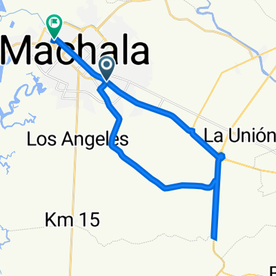
Route highlights
Points of interest along the route
Bike service after 0.7 km
CEVICHERIA EL MANABA
Bike service after 3.4 km
MUELLE
Bike service after 6.8 km
CUARTEL GENERAL FESTIVAL DE ARTE EN VIVO AL AIRE LIBRE MACHALA - BANANART 21-27 SEPT/15
Bike service after 11.5 km
TIA CIRCUNVALACIÓN NORTE
Bike service after 14.2 km
Bike n Roads
Bike service after 15.9 km
PARQUE COLON / CENTRO DE MACHALA
Bike service after 16.8 km
PARQUE CENTRAL
Bike service after 17.4 km
PARQUE TANQUE ROJO - CENTRO
Bike service after 19.5 km
PARQUE LINEAL
Continue with Bikemap
Use, edit, or download this cycling route
You would like to ride ALLEYCAT - El Bananero - FESTIVAL DE ARTE EN VIVO AL AIRE LIBRE or customize it for your own trip? Here is what you can do with this Bikemap route:
Free features
- Save this route as favorite or in collections
- Copy & plan your own version of this route
- Sync your route with Garmin or Wahoo
Premium features
Free trial for 3 days, or one-time payment. More about Bikemap Premium.
- Navigate this route on iOS & Android
- Export a GPX / KML file of this route
- Create your custom printout (try it for free)
- Download this route for offline navigation
Discover more Premium features.
Get Bikemap PremiumFrom our community
Other popular routes starting in Machala
 De P38V+7F3 a P38V+7F3
- Distance
- 11.1 km
- Ascent
- 85 m
- Descent
- 101 m
- Location
- Machala, El Oro, Ecuador
 Machala - Huaquillas
- Distance
- 74.9 km
- Ascent
- 69 m
- Descent
- 80 m
- Location
- Machala, El Oro, Ecuador
 De P38V+FHP, El Cambio a Avenida Ferroviaria, El Cambio
- Distance
- 13.3 km
- Ascent
- 93 m
- Descent
- 107 m
- Location
- Machala, El Oro, Ecuador
 De Avenida Circunvalación Sur, Machala a Avenida 15ava A Sur 215, Machala
- Distance
- 36.5 km
- Ascent
- 302 m
- Descent
- 315 m
- Location
- Machala, El Oro, Ecuador
 De E583, Machala a Carrera 12ava Oeste, Machala
- Distance
- 29.1 km
- Ascent
- 164 m
- Descent
- 167 m
- Location
- Machala, El Oro, Ecuador
 De Vía Pajonal a Carrera 2da. Este, Machala
- Distance
- 27.3 km
- Ascent
- 360 m
- Descent
- 377 m
- Location
- Machala, El Oro, Ecuador
 Ruta a P38V+7F3
- Distance
- 11.4 km
- Ascent
- 68 m
- Descent
- 81 m
- Location
- Machala, El Oro, Ecuador
Open it in the app