

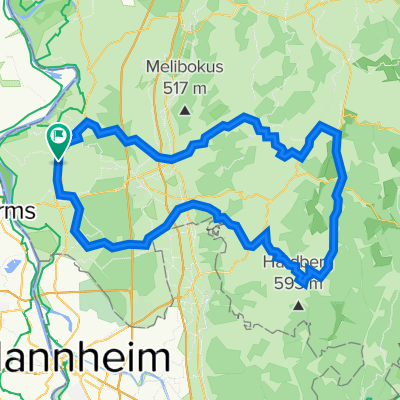
20150726_141636.gpx
A cycling route starting in Biblis, Hesse, Germany.
Overview
About this route
TEASI track
- -:--
- Duration
- 7.6 km
- Distance
- 10 m
- Ascent
- 20 m
- Descent
- ---
- Avg. speed
- ---
- Max. altitude
Route quality
Waytypes & surfaces along the route
Waytypes
Path
2.4 km
(32 %)
Track
2.1 km
(28 %)
Surfaces
Paved
7.2 km
(95 %)
Asphalt
6.5 km
(86 %)
Concrete
0.6 km
(8 %)
Continue with Bikemap
Use, edit, or download this cycling route
You would like to ride 20150726_141636.gpx or customize it for your own trip? Here is what you can do with this Bikemap route:
Free features
- Save this route as favorite or in collections
- Copy & plan your own version of this route
- Sync your route with Garmin or Wahoo
Premium features
Free trial for 3 days, or one-time payment. More about Bikemap Premium.
- Navigate this route on iOS & Android
- Export a GPX / KML file of this route
- Create your custom printout (try it for free)
- Download this route for offline navigation
Discover more Premium features.
Get Bikemap PremiumFrom our community
Other popular routes starting in Biblis
 Nach Biblis ersatz
- Distance
- 19.9 km
- Ascent
- 14 m
- Descent
- 13 m
- Location
- Biblis, Hesse, Germany
 FlussRadWege
- Distance
- 485.6 km
- Ascent
- 2,706 m
- Descent
- 2,706 m
- Location
- Biblis, Hesse, Germany
 Friedhofstraße 6, Biblis nach Karlstraße 6, Biblis
- Distance
- 8.3 km
- Ascent
- 9 m
- Descent
- 10 m
- Location
- Biblis, Hesse, Germany
 Hessen - Pfalz Route
- Distance
- 28.7 km
- Ascent
- 200 m
- Descent
- 87 m
- Location
- Biblis, Hesse, Germany
 Norde-13
- Distance
- 13 km
- Ascent
- 36 m
- Descent
- 39 m
- Location
- Biblis, Hesse, Germany
 Norde-33
- Distance
- 33.5 km
- Ascent
- 39 m
- Descent
- 39 m
- Location
- Biblis, Hesse, Germany
 Weschnitz-Rundfahrt
- Distance
- 109.7 km
- Ascent
- 920 m
- Descent
- 920 m
- Location
- Biblis, Hesse, Germany
 L3261 40, Biblis nach Neuländer Pfad 5, Biblis
- Distance
- 13.4 km
- Ascent
- 17 m
- Descent
- 18 m
- Location
- Biblis, Hesse, Germany
Open it in the app