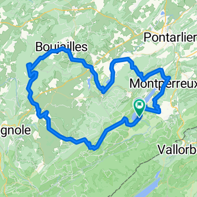
Les Alpages par les crĂȘtes
A cycling route starting in Jougne, Bourgogne-Franche-Comté, France.
Overview
About this route
From the Grand Tétras, a beautiful discovery circuit with interesting elevations and technical sections. Great view of the lake. by mountain bike or electric bike.
- -:--
- Duration
- 21.7 km
- Distance
- 686 m
- Ascent
- 686 m
- Descent
- ---
- Avg. speed
- ---
- Max. altitude
Continue with Bikemap
Use, edit, or download this cycling route
You would like to ride Les Alpages par les crĂȘtes or customize it for your own trip? Here is what you can do with this Bikemap route:
Free features
- Save this route as favorite or in collections
- Copy & plan your own version of this route
- Sync your route with Garmin or Wahoo
Premium features
Free trial for 3 days, or one-time payment. More about Bikemap Premium.
- Navigate this route on iOS & Android
- Export a GPX / KML file of this route
- Create your custom printout (try it for free)
- Download this route for offline navigation
Discover more Premium features.
Get Bikemap PremiumFrom our community
Other popular routes starting in Jougne
- Jura Tour: Malbuisson -> Les Molunes
- Distance
- 92.2 km
- Ascent
- 1,403 m
- Descent
- 1,078 m
- Location
- Jougne, Bourgogne-Franche-Comté, France
- around Saint-point lake
- Distance
- 23.7 km
- Ascent
- 139 m
- Descent
- 122 m
- Location
- Jougne, Bourgogne-Franche-Comté, France
- HĂŽpitaux Neufs Mots du Jura F/CH
- Distance
- 85.3 km
- Ascent
- 1,636 m
- Descent
- 1,634 m
- Location
- Jougne, Bourgogne-Franche-Comté, France
- Remoray Lac
- Distance
- 117.8 km
- Ascent
- 1,943 m
- Descent
- 1,941 m
- Location
- Jougne, Bourgogne-Franche-Comté, France
- Lac de Remoray-Mouthe
- Distance
- 48.4 km
- Ascent
- 723 m
- Descent
- 649 m
- Location
- Jougne, Bourgogne-Franche-Comté, France
- Grande Traversée du Jura - Etape 3 : Métabief / Les Rousses (65 km / D+ 1300 m)
- Distance
- 64.9 km
- Ascent
- 1,028 m
- Descent
- 887 m
- Location
- Jougne, Bourgogne-Franche-Comté, France
- Jura Val de Mouthe
- Distance
- 30 km
- Ascent
- 429 m
- Descent
- 430 m
- Location
- Jougne, Bourgogne-Franche-Comté, France
- lac st-point tour
- Distance
- 20.1 km
- Ascent
- 177 m
- Descent
- 163 m
- Location
- Jougne, Bourgogne-Franche-Comté, France
Open it in the app