

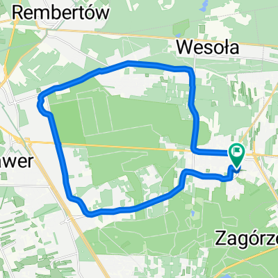
Iron Loop
A cycling route starting in Sulejówek, Masovian Voivodeship, Poland.
Overview
About this route
Trasa w zasadzie to i na szosówkę się nada. Bardzo przyjemna, łatwa traska, z dodatkową atrakcą w postaci przeprawy promowej
- -:--
- Duration
- 65.2 km
- Distance
- 47 m
- Ascent
- 47 m
- Descent
- ---
- Avg. speed
- ---
- Max. altitude

Route quality
Waytypes & surfaces along the route
Waytypes
Quiet road
16.3 km
(25 %)
Road
13.7 km
(21 %)
Surfaces
Paved
39.1 km
(60 %)
Unpaved
4.6 km
(7 %)
Asphalt
37.2 km
(57 %)
Concrete
2 km
(3 %)
Continue with Bikemap
Use, edit, or download this cycling route
You would like to ride Iron Loop or customize it for your own trip? Here is what you can do with this Bikemap route:
Free features
- Save this route as favorite or in collections
- Copy & plan your own version of this route
- Sync your route with Garmin or Wahoo
Premium features
Free trial for 3 days, or one-time payment. More about Bikemap Premium.
- Navigate this route on iOS & Android
- Export a GPX / KML file of this route
- Create your custom printout (try it for free)
- Download this route for offline navigation
Discover more Premium features.
Get Bikemap PremiumFrom our community
Other popular routes starting in Sulejówek
 trasa historyczna
- Distance
- 18.9 km
- Ascent
- 26 m
- Descent
- 23 m
- Location
- Sulejówek, Masovian Voivodeship, Poland
 Skarpa
- Distance
- 40.1 km
- Ascent
- 342 m
- Descent
- 348 m
- Location
- Sulejówek, Masovian Voivodeship, Poland
 stm-międz-anin-mar-wesł
- Distance
- 19.1 km
- Ascent
- 775 m
- Descent
- 751 m
- Location
- Sulejówek, Masovian Voivodeship, Poland
 A bit bigger training loop with ice-cream break :)
- Distance
- 30.4 km
- Ascent
- 68 m
- Descent
- 70 m
- Location
- Sulejówek, Masovian Voivodeship, Poland
 Góry Chobockie
- Distance
- 36.7 km
- Ascent
- 449 m
- Descent
- 445 m
- Location
- Sulejówek, Masovian Voivodeship, Poland
 Wycieczka_ProEvent_Warszawa
- Distance
- 22.6 km
- Ascent
- 49 m
- Descent
- 48 m
- Location
- Sulejówek, Masovian Voivodeship, Poland
 trasa historyczna Sulejówek
- Distance
- 18.9 km
- Ascent
- 26 m
- Descent
- 23 m
- Location
- Sulejówek, Masovian Voivodeship, Poland
 Iron Loop
- Distance
- 65.2 km
- Ascent
- 47 m
- Descent
- 47 m
- Location
- Sulejówek, Masovian Voivodeship, Poland
Open it in the app