

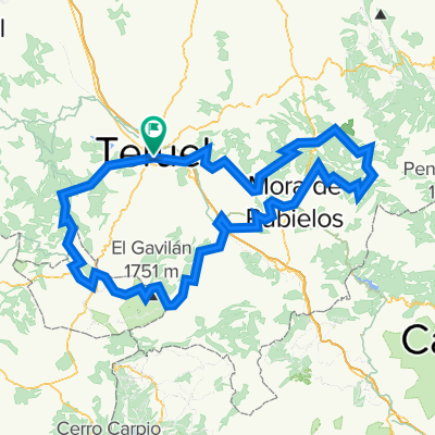
Teruel-4puertos-Tronchón
A cycling route starting in Teruel, Aragon, Spain.
Overview
About this route
Teruel-Puerto Cabigordo-Puerto Sollavientos-Puerto Villarroya-Puerto CuartoPelado-Tronchón
- -:--
- Duration
- 126.9 km
- Distance
- 1,947 m
- Ascent
- 1,805 m
- Descent
- ---
- Avg. speed
- ---
- Max. altitude

Route quality
Waytypes & surfaces along the route
Waytypes
Quiet road
16.5 km
(13 %)
Road
7.6 km
(6 %)
Surfaces
Paved
38.1 km
(30 %)
Asphalt
34.3 km
(27 %)
Paved (undefined)
3.8 km
(3 %)
Undefined
88.8 km
(70 %)
Continue with Bikemap
Use, edit, or download this cycling route
You would like to ride Teruel-4puertos-Tronchón or customize it for your own trip? Here is what you can do with this Bikemap route:
Free features
- Save this route as favorite or in collections
- Copy & plan your own version of this route
- Split it into stages to create a multi-day tour
- Sync your route with Garmin or Wahoo
Premium features
Free trial for 3 days, or one-time payment. More about Bikemap Premium.
- Navigate this route on iOS & Android
- Export a GPX / KML file of this route
- Create your custom printout (try it for free)
- Download this route for offline navigation
Discover more Premium features.
Get Bikemap PremiumFrom our community
Other popular routes starting in Teruel
 Teruel-Dernaque-Valdecuenca-Toril-Javalambre-Teruel
- Distance
- 195.1 km
- Ascent
- 2,119 m
- Descent
- 2,127 m
- Location
- Teruel, Aragon, Spain
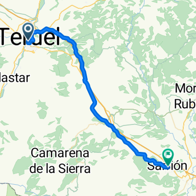 Day 1: Teruel - Sarrión
- Distance
- 44.4 km
- Ascent
- 559 m
- Descent
- 484 m
- Location
- Teruel, Aragon, Spain
 MV3.1-jhl
- Distance
- 155.5 km
- Ascent
- 1,911 m
- Descent
- 1,680 m
- Location
- Teruel, Aragon, Spain
 Teruel - Sant Carles de la Rapita 241km Vuelta Mine is 259
- Distance
- 260.7 km
- Ascent
- 2,611 m
- Descent
- 3,510 m
- Location
- Teruel, Aragon, Spain
 Montañas Vacías 1-5
- Distance
- 675 km
- Ascent
- 14,002 m
- Descent
- 14,002 m
- Location
- Teruel, Aragon, Spain
 castelfabib>teruel
- Distance
- 276 km
- Ascent
- 6,300 m
- Descent
- 6,302 m
- Location
- Teruel, Aragon, Spain
 Teruel-4puertos-Tronchón
- Distance
- 126.9 km
- Ascent
- 1,947 m
- Descent
- 1,805 m
- Location
- Teruel, Aragon, Spain
 Teruel-Sagunto
- Distance
- 149.5 km
- Ascent
- 379 m
- Descent
- 1,257 m
- Location
- Teruel, Aragon, Spain
Open it in the app