

3 Stunden Strecke
A cycling route starting in Bühlertal, Baden-Wurttemberg, Germany.
Overview
About this route
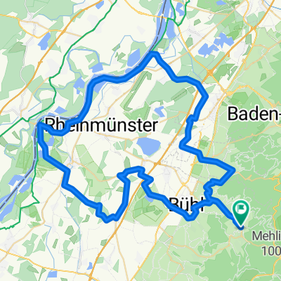
Bühlertal - Sickenwald - Hundseck - Unterstmatt - Hornisgrinde - Mummelsee - Unterstmatt - Hundseck - Kappler Wald - Immenstein
- -:--
- Duration
- 36.5 km
- Distance
- 958 m
- Ascent
- 958 m
- Descent
- ---
- Avg. speed
- ---
- Max. altitude
Route highlights
Points of interest along the route

Point of interest after 9.6 km
Blick nach Bühlertal

Point of interest after 12.7 km
hier wirds richtig hart! links gehts weiter

Point of interest after 13.3 km
Das Ziel vor Augen!

Point of interest after 13.5 km
Hornisgrindeturm
Continue with Bikemap
Use, edit, or download this cycling route
You would like to ride 3 Stunden Strecke or customize it for your own trip? Here is what you can do with this Bikemap route:
Free features
- Save this route as favorite or in collections
- Copy & plan your own version of this route
- Sync your route with Garmin or Wahoo
Premium features
Free trial for 3 days, or one-time payment. More about Bikemap Premium.
- Navigate this route on iOS & Android
- Export a GPX / KML file of this route
- Create your custom printout (try it for free)
- Download this route for offline navigation
Discover more Premium features.
Get Bikemap PremiumFrom our community
Other popular routes starting in Bühlertal
 Permanente Bühlertal-Rheintal Tour
- Distance
- 69.8 km
- Ascent
- 290 m
- Descent
- 404 m
- Location
- Bühlertal, Baden-Wurttemberg, Germany
 Schwimmbad Bühlertal - Hornisgrinde Rundweg
- Distance
- 44.4 km
- Ascent
- 1,131 m
- Descent
- 1,128 m
- Location
- Bühlertal, Baden-Wurttemberg, Germany
 Permanente Nordschwarzwald Total
- Distance
- 96.4 km
- Ascent
- 2,301 m
- Descent
- 2,080 m
- Location
- Bühlertal, Baden-Wurttemberg, Germany
 3 Stunden Strecke
- Distance
- 36.5 km
- Ascent
- 958 m
- Descent
- 958 m
- Location
- Bühlertal, Baden-Wurttemberg, Germany
 Von Bühlertal bis Bundenthal
- Distance
- 145.1 km
- Ascent
- 1,902 m
- Descent
- 2,204 m
- Location
- Bühlertal, Baden-Wurttemberg, Germany
 Schnelle Ausfahrt durch Baden-Baden
- Distance
- 1 km
- Ascent
- 56 m
- Descent
- 61 m
- Location
- Bühlertal, Baden-Wurttemberg, Germany
 Mountainbiketour 005 mit 33Km und 950Hm
- Distance
- 32.1 km
- Ascent
- 868 m
- Descent
- 868 m
- Location
- Bühlertal, Baden-Wurttemberg, Germany
 Drei Täler Tour
- Distance
- 74.9 km
- Ascent
- 2,435 m
- Descent
- 2,342 m
- Location
- Bühlertal, Baden-Wurttemberg, Germany
Open it in the app