

20150730_153045.gpx
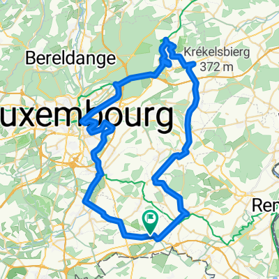
A cycling route starting in Aspelt, District de Luxembourg, Luxembourg.
Overview
About this route
TEASI track
- -:--
- Duration
- 35.7 km
- Distance
- 251 m
- Ascent
- 252 m
- Descent
- ---
- Avg. speed
- ---
- Max. altitude
clawilux
created this 10 years ago
Route quality
Waytypes & surfaces along the route
Waytypes
Track
15.4 km
43 %
Quiet road
6.8 km
19 %
Surfaces
Paved
33.6 km
(94 %)
Unpaved
2.1 km
(6 %)
Asphalt
23.9 km
67 %
Paved (undefined)
9.6 km
27 %
Continue with Bikemap
Use, edit, or download this cycling route
You would like to ride 20150730_153045.gpx or customize it for your own trip? Here is what you can do with this Bikemap route:
Free features
- Save this route as favorite or in collections
- Copy & plan your own version of this route
- Sync your route with Garmin or Wahoo
Premium features
Free trial for 3 days, or one-time payment. More about Bikemap Premium.
- Navigate this route on iOS & Android
- Export a GPX / KML file of this route
- Create your custom printout (try it for free)
- Download this route for offline navigation
Discover more Premium features.
Get Bikemap PremiumFrom our community
Other popular routes starting in Aspelt
- Op Waasserkierten 23, Frisingen nach Rue de Livange, Bettemburg
- 10.9 km
- 77 m
- 45 m
- Aspelt, District de Luxembourg, Luxembourg


Open it in the app