Kastellaun - Lahr - Treis-Karden - Brohl - Landkern - Cochem - Beilstein - Blankenrath - Mastershausen - Kastellaun
A cycling route starting in Kastellaun, Rhineland-Palatinate, Germany.
Overview
About this route
Start- & Zielort: Burgstadthotel Kastellaun
- -:--
- Duration
- 107.2 km
- Distance
- 1,231 m
- Ascent
- 1,230 m
- Descent
- ---
- Avg. speed
- ---
- Avg. speed
Route quality
Waytypes & surfaces along the route
Waytypes
Busy road
61.7 km
(57 %)
Road
35.2 km
(33 %)
Surfaces
Paved
95.2 km
(89 %)
Unpaved
0.8 km
(<1 %)
Asphalt
94.2 km
(88 %)
Paved (undefined)
0.7 km
(<1 %)
Continue with Bikemap
Use, edit, or download this cycling route
You would like to ride Kastellaun - Lahr - Treis-Karden - Brohl - Landkern - Cochem - Beilstein - Blankenrath - Mastershausen - Kastellaun or customize it for your own trip? Here is what you can do with this Bikemap route:
Free features
- Save this route as favorite or in collections
- Copy & plan your own version of this route
- Sync your route with Garmin or Wahoo
Premium features
Free trial for 3 days, or one-time payment. More about Bikemap Premium.
- Navigate this route on iOS & Android
- Export a GPX / KML file of this route
- Create your custom printout (try it for free)
- Download this route for offline navigation
Discover more Premium features.
Get Bikemap PremiumFrom our community
Other popular routes starting in Kastellaun
- 2016 
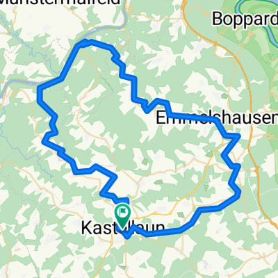
Schinderhannes Radweg Hunsrück
- Distance
- 46.3 km
- Ascent
- 275 m
- Descent
- 275 m
- Location
- Kastellaun, Rhineland-Palatinate, Germany
- Kastellaun_4-Tagestour_Krabbelgruppe_Tag1_Tour_a
- Distance
- 53.3 km
- Ascent
- 629 m
- Descent
- 630 m
- Location
- Kastellaun, Rhineland-Palatinate, Germany
- 2016-09-10_Sommerfest_Krabbelgruppe
- Distance
- 88 km
- Ascent
- 992 m
- Descent
- 992 m
- Location
- Kastellaun, Rhineland-Palatinate, Germany
- Kastellaun_4-Tagefahrt_Tour3_Verfolger
- Distance
- 118.8 km
- Ascent
- 921 m
- Descent
- 921 m
- Location
- Kastellaun, Rhineland-Palatinate, Germany
- Ausfahrt durch Kastellaun
- Distance
- 26.6 km
- Ascent
- 328 m
- Descent
- 328 m
- Location
- Kastellaun, Rhineland-Palatinate, Germany
- Schinderhannespfad
- Distance
- 37.4 km
- Ascent
- 570 m
- Descent
- 756 m
- Location
- Kastellaun, Rhineland-Palatinate, Germany
- Kastellaun - Lahr - Treis-Karden - Brohl - Landkern - Cochem - Beilstein - Blankenrath - Mastershausen - Kastellaun
- Distance
- 107.2 km
- Ascent
- 1,231 m
- Descent
- 1,230 m
- Location
- Kastellaun, Rhineland-Palatinate, Germany
- Burgstadt-Pfad
- Distance
- 6.7 km
- Ascent
- 82 m
- Descent
- 87 m
- Location
- Kastellaun, Rhineland-Palatinate, Germany
Open it in the app