

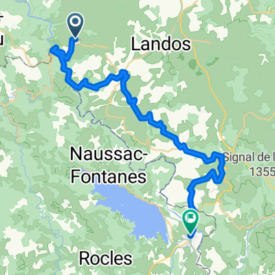
7. Chapeauroux - Saint-Chély d'Apcher
A cycling route starting in Langogne, Occitanie, France.
Overview
About this route
- Chapeauroux - Saint-Chély d'Apcher (cloned from route 3196890)
- -:--
- Duration
- 55.6 km
- Distance
- 896 m
- Ascent
- 713 m
- Descent
- ---
- Avg. speed
- ---
- Max. altitude

Route quality
Waytypes & surfaces along the route
Waytypes
Road
5.6 km
(10 %)
Quiet road
3.3 km
(6 %)
Surfaces
Paved
11.1 km
(20 %)
Unpaved
1.7 km
(3 %)
Asphalt
11.1 km
(20 %)
Gravel
1.7 km
(3 %)
Undefined
42.8 km
(77 %)
Continue with Bikemap
Use, edit, or download this cycling route
You would like to ride 7. Chapeauroux - Saint-Chély d'Apcher or customize it for your own trip? Here is what you can do with this Bikemap route:
Free features
- Save this route as favorite or in collections
- Copy & plan your own version of this route
- Sync your route with Garmin or Wahoo
Premium features
Free trial for 3 days, or one-time payment. More about Bikemap Premium.
- Navigate this route on iOS & Android
- Export a GPX / KML file of this route
- Create your custom printout (try it for free)
- Download this route for offline navigation
Discover more Premium features.
Get Bikemap PremiumFrom our community
Other popular routes starting in Langogne
 Saint Bonnet, Chapeauroux, Joncherette
- Distance
- 40.5 km
- Ascent
- 625 m
- Descent
- 610 m
- Location
- Langogne, Occitanie, France
 2011 Langogne-Cahors en Vélofamille 3 enfants
- Distance
- 296.8 km
- Ascent
- 1,110 m
- Descent
- 1,888 m
- Location
- Langogne, Occitanie, France
 Et. 7 Saint-Haon / Langogne
- Distance
- 34.1 km
- Ascent
- 1,052 m
- Descent
- 1,136 m
- Location
- Langogne, Occitanie, France
 2015 L'Allier-Loire-Canal du Centre
- Distance
- 568.4 km
- Ascent
- 759 m
- Descent
- 1,745 m
- Location
- Langogne, Occitanie, France
 Le Gerbier de Jonc
- Distance
- 126.6 km
- Ascent
- 2,993 m
- Descent
- 2,992 m
- Location
- Langogne, Occitanie, France
 7. Chapeauroux - Saint-Chély d'Apcher
- Distance
- 55.6 km
- Ascent
- 896 m
- Descent
- 713 m
- Location
- Langogne, Occitanie, France
 Tour du Lac
- Distance
- 28 km
- Ascent
- 360 m
- Descent
- 364 m
- Location
- Langogne, Occitanie, France
 02ColduChevalMort
- Distance
- 116 km
- Ascent
- 1,944 m
- Descent
- 1,945 m
- Location
- Langogne, Occitanie, France
Open it in the app