

Stever Radweg - Burg und Saline im Ruhrgebiet
A cycling route starting in Haltern am See, North Rhine-Westphalia, Germany.
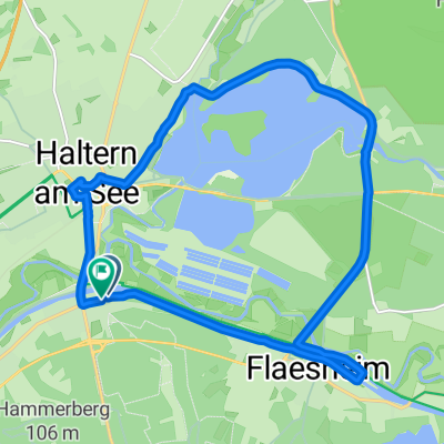
Overview
About this route
Simply let your gaze wander, quietly observe how a world develops that is not shaped by human hands. Peacefully grazing and undisturbed nature. The Steveraue offers you a unique natural experience that you can enjoy with all your senses.
- -:--
- Duration
- 62 km
- Distance
- 146 m
- Ascent
- 120 m
- Descent
- ---
- Avg. speed
- ---
- Max. altitude

Route quality
Waytypes & surfaces along the route
Waytypes
Quiet road
24.2 km
(39 %)
Path
23.6 km
(38 %)
Surfaces
Paved
40.9 km
(66 %)
Unpaved
17.4 km
(28 %)
Asphalt
40.3 km
(65 %)
Gravel
15.5 km
(25 %)
Route highlights
Points of interest along the route

Photo after 2.3 km
Halterner Stausee

Photo after 9.3 km
Stever

Photo after 27.9 km
Burg Vischering

Photo after 39.8 km
Schloß Nordkirchen

Photo after 53.9 km
Saline bei Werne
Continue with Bikemap
Use, edit, or download this cycling route
You would like to ride Stever Radweg - Burg und Saline im Ruhrgebiet or customize it for your own trip? Here is what you can do with this Bikemap route:
Free features
- Save this route as favorite or in collections
- Copy & plan your own version of this route
- Sync your route with Garmin or Wahoo
Premium features
Free trial for 3 days, or one-time payment. More about Bikemap Premium.
- Navigate this route on iOS & Android
- Export a GPX / KML file of this route
- Create your custom printout (try it for free)
- Download this route for offline navigation
Discover more Premium features.
Get Bikemap PremiumFrom our community
Other popular routes starting in Haltern am See
 Stever Radweg - Burg und Saline im Ruhrgebiet
- Distance
- 62 km
- Ascent
- 146 m
- Descent
- 120 m
- Location
- Haltern am See, North Rhine-Westphalia, Germany
 rondje halteren
- Distance
- 53.1 km
- Ascent
- 348 m
- Descent
- 347 m
- Location
- Haltern am See, North Rhine-Westphalia, Germany
 Holtkampweg nach Holtkampweg
- Distance
- 16.1 km
- Ascent
- 36 m
- Descent
- 85 m
- Location
- Haltern am See, North Rhine-Westphalia, Germany
 D - Dülmen - F04 - 35 km CLONED FROM ROUTE 910005
- Distance
- 35.2 km
- Ascent
- 99 m
- Descent
- 93 m
- Location
- Haltern am See, North Rhine-Westphalia, Germany
 Haltern am See kleine Seen Tour
- Distance
- 23.5 km
- Ascent
- 84 m
- Descent
- 78 m
- Location
- Haltern am See, North Rhine-Westphalia, Germany
 Rund um Haltern
- Distance
- 48.8 km
- Ascent
- 136 m
- Descent
- 128 m
- Location
- Haltern am See, North Rhine-Westphalia, Germany
 Haard On Tour
- Distance
- 41.5 km
- Ascent
- 631 m
- Descent
- 631 m
- Location
- Haltern am See, North Rhine-Westphalia, Germany
 Haltern am See
- Distance
- 12 km
- Ascent
- 62 m
- Descent
- 59 m
- Location
- Haltern am See, North Rhine-Westphalia, Germany
Open it in the app